IMAGES TAKEN NEAR TO
Harewood Avenue, LONDON, NW1 6PA
Introduction
This page details the photographs taken nearby to Harewood Avenue, NW1 6PA by members of the Geograph project.
The Geograph project started in 2005 with the aim of publishing, organising and preserving representative images for every square kilometre of Great Britain, Ireland and the Isle of Man.

There are currently over 7.5m images from over14,400 individuals and you can help contribute to the project by visiting https://www.geograph.org.uk
Image Map (Loading...)


Getting Data...Please wait
Leaflet Map data © OpenStreetMap
Images are licensed for reuse under creativecommons.org/licenses/by-sa/2.0
Notes
- Clicking on the map will re-center to the selected point.
- The higher the marker number, the further away the image location is from the centre of the postcode.
Image Listing (754 Images Found)
Images are licensed for reuse under creativecommons.org/licenses/by-sa/2.0
Image
Details
Distance
1
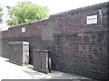
Brick wall with signs warning of ?anti climb paint?, north end of Harewood Avenue
I think it is just on the equipment boxes, which could aid climbing the wall. The signs are not simply deterrent: anti-climb paint is a real material. It is a thick oily coating that does not dry out, thus remaining slippery indefinitely, according to http://en.wikipedia.org/wiki/Anti-climb_paint
Image: © Robin Stott
Taken: 3 Aug 2014
0.01 miles
3
Works to power cables, Harewood Avenue
Services go through, round and under this tree, a relatively young Ginkgo. It's looking poorly; I think it's a goner. It is seen from the opposite direction in Image The postbox in the background is number NW1 24.
Image: © Robin Stott
Taken: 3 Aug 2014
0.03 miles
4
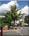
Sickly ginkgo, Harewood Place
Ginkgo (Ginkgo biloba) is having a long drawn-out vogue as a street tree because of its open crown and upright habit. Judging by its yellowing foliage, this specimen is poorly: doubtless affected by the brutal excavations around it for electricity cables http://www.geograph.org.uk/photo/4104477 In my view it's a goner.
The postbox number is NW1 24.
Image: © Robin Stott
Taken: 3 Aug 2014
0.03 miles
5
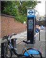
Cycle hire station, northeast end of Broadley Terrace
Image: © Robin Stott
Taken: 3 Aug 2014
0.03 miles
6
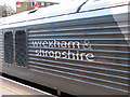
Wrexham & Shropshire Railway locomotive branding
Seen here at Marylebone on one of the company's class 67 locomotives.
Image: © John Lucas
Taken: 2 May 2008
0.05 miles
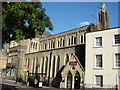
9
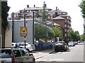
Two flavours of modern, Broadley Terrace
The purpose of the foreground building could not be deduced (school?) but its style is in contrast to the huge Portman Gate apartment block beyond it. A commemorative stone in Broadley Terrace records that Portman Gate was opened by John Patten MP, Minister for Housing, Urban Affairs and Construction on the 22nd May 1986. Developer: Declan Kelly Group. Architects: Phippen Randall and Parkes.
Image: © Robin Stott
Taken: 3 Aug 2014
0.05 miles
10
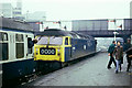
The locomotive arrives for a Merrymaker Mystery Tour, 1976
Rossmore Road bridge is beyond. The ramp beyond the people on the platform on the other side of the bridge appears to be part of a hairpin access road from Rossmore Road to the platform, which was (is?) very wide. The mystery destination turned out to be Carlisle.
Image: © Robin Webster
Taken: Unknown
0.06 miles