IMAGES TAKEN NEAR TO
Lisson Street, LONDON, NW1 5DA
Introduction
This page details the photographs taken nearby to Lisson Street, NW1 5DA by members of the Geograph project.
The Geograph project started in 2005 with the aim of publishing, organising and preserving representative images for every square kilometre of Great Britain, Ireland and the Isle of Man.

There are currently over 7.5m images from over14,400 individuals and you can help contribute to the project by visiting https://www.geograph.org.uk
Image Map
Images are licensed for reuse under creativecommons.org/licenses/by-sa/2.0
Notes
- Clicking on the map will re-center to the selected point.
- The higher the marker number, the further away the image location is from the centre of the postcode.
Image Listing (669 Images Found)
Images are licensed for reuse under creativecommons.org/licenses/by-sa/2.0
Image
Details
Distance
1
Faint vestiges of former street names, London NW1
The current street name signs show Bell Street on the left and Daventry Street ahead.
Faint traces of earlier names remain in the walls above the newer signs.
Bell Street was formerly Bendall Street and Daventry Street was formerly William Street.
Image: © Jaggery
Taken: 12 May 2012
0.01 miles


4
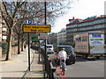
Dust Suppressant Trial Site, Marylebone Rd (West end)
The Marylebone and Euston Roads have high levels of pollution of dust caused by traffic, engine emissions and tyre and brake wear. An experiment is under way of spraying a solution of Calcium Magnesium Acetate on the road. The dust is supposed to stick to the treated road surface, which is swept, washed and sprayed several times per week in the early hours. See press releases from the Mayor of London http://www.london.gov.uk/media/press_releases_mayoral/uk-first-innovative-trial-reduce-london%E2%80%99s-air-pollution-gets-underway and Transport for London http://www.tfl.gov.uk/corporate/projectsandschemes/17246.aspx . This photo is on the Marylebone Road as traffic comes down from the Marylebone Flyover, or in from the Harrow Road.
Image: © David Hawgood
Taken: 24 Mar 2011
0.04 miles
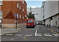
5
Slow, slow, quick, quick, slower (151)
Looking towards the crossroads of Bell and Daventry Streets
Image: © Basher Eyre
Taken: 23 Apr 2016
0.04 miles
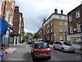
6
Slow, slow, quick, quick, slower (150)
Approaching the junction of Ranston and Bell Streets
Image: © Basher Eyre
Taken: 23 Apr 2016
0.04 miles
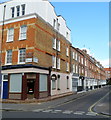
7
Lisson Street, Marylebone
View from Marylebone Road.
Image: © David Hawgood
Taken: 24 Mar 2011
0.04 miles
8
Traffic heading westwards towards the Marylebone Flyover
From here, traffic heading westwards soon finds itself on the elevated Westway.
Image: © Christopher Hilton
Taken: 20 Jan 2011
0.05 miles
9
The end of the Marylebone flyover
Above Edgware Road tube station.
Image: © Andrew Abbott
Taken: 4 Apr 2019
0.05 miles