IMAGES TAKEN NEAR TO
Augustus Street, LONDON, NW1 3TA
Introduction
This page details the photographs taken nearby to Augustus Street, NW1 3TA by members of the Geograph project.
The Geograph project started in 2005 with the aim of publishing, organising and preserving representative images for every square kilometre of Great Britain, Ireland and the Isle of Man.

There are currently over 7.5m images from over14,400 individuals and you can help contribute to the project by visiting https://www.geograph.org.uk
Image Map
Images are licensed for reuse under creativecommons.org/licenses/by-sa/2.0
Notes
- Clicking on the map will re-center to the selected point.
- The higher the marker number, the further away the image location is from the centre of the postcode.
Image Listing (264 Images Found)
Images are licensed for reuse under creativecommons.org/licenses/by-sa/2.0
Image
Details
Distance
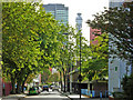
1
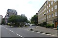
Augustus Street
Looking towards BT Tower in the distance.
Image: © DS Pugh
Taken: 24 Jul 2014
0.03 miles
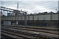
3
Stanhope Street, Camden Town
The fence hides a railway which is currently being redeveloped.
Image: © David Howard
Taken: 9 May 2020
0.04 miles
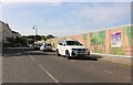
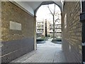
4
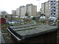
Allotments on the Regent's Park Estate
These allotments are bordered on three sides by blocks of flats and by the Regent's Park Barracks on the fourth side (the north) Managed by Camden Council, they are much sought after with long waiting lists.
Image: © Sheila Madhvani
Taken: 13 Jan 2009
0.05 miles
5
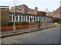
Christchurch Primary School
Primary school in Redhill Street on the Regent's Park Estate.
Image: © Sheila Madhvani
Taken: 16 Feb 2009
0.05 miles
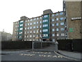
9

Albany Street Barracks
The Barracks in Albany Street originally housed cavalry which was relocated to St John's Wood Barracks in the latter part of the 20th century.
Image: © Sheila Madhvani
Taken: 27 Jan 2009
0.07 miles
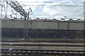
10
Stanhope Street, Euston
Stanhope Street runs parallel with Hampstead Road; Euston Tower and the more distinctive BT Tower can be seen in the background.
Image: © Stephen McKay
Taken: 18 Oct 2007
0.08 miles