IMAGES TAKEN NEAR TO
Harrington Street, LONDON, NW1 3SJ
Introduction
This page details the photographs taken nearby to Harrington Street, NW1 3SJ by members of the Geograph project.
The Geograph project started in 2005 with the aim of publishing, organising and preserving representative images for every square kilometre of Great Britain, Ireland and the Isle of Man.

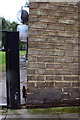
There are currently over 7.5m images from over14,400 individuals and you can help contribute to the project by visiting https://www.geograph.org.uk
Image Map
Images are licensed for reuse under creativecommons.org/licenses/by-sa/2.0
Notes
- Clicking on the map will re-center to the selected point.
- The higher the marker number, the further away the image location is from the centre of the postcode.
Image Listing (492 Images Found)
Images are licensed for reuse under creativecommons.org/licenses/by-sa/2.0
Image
Details
Distance
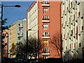
1
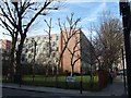
Block of flats on Hampstead Road
The trees were bare in March, but they will provide some screening of the site when their leaves are out.
Image: © David Smith
Taken: 24 Mar 2011
0.03 miles
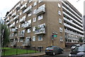
2
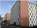
Blocks of flats in the Regent's Park Estate
I found the symmetry of these blocks in Camden very appealing.
Image: © Sheila Madhvani
Taken: 16 Feb 2009
0.03 miles
3
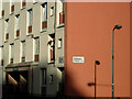
Hawkshead Block, Regent's Park Estate
On the corner of Stanhope Street and Varndell Street. Many of the blocks on this large estate have been given names from the Lake District; unfortunately, they don't endow the brutalist architecture with beauty.
Image: © Stephen McKay
Taken: 16 Jan 2008
0.03 miles
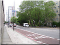
4
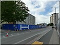
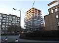
Hampstead Road, constricted
Hoardings for construction of the new high-speed rail terminus at Euston have constrained the road into one traffic lane (subject to traffic lights controlling alternate directions) and a cycle lane in each direction.
Image: © Stephen Craven
Taken: 28 Jun 2022
0.03 miles
5
Benchmark on 'The Tarns', Varndell Street
Ordnance Survey cut mark benchmark described on the Bench Mark Database at http://www.bench-marks.org.uk/bm39280
Image: © Roger Templeman
Taken: 20 Aug 2011
0.04 miles
6
'The Tarns', Varndell Street
There is an OS benchmark Image near the corner of the building
Image: © Roger Templeman
Taken: 20 Aug 2011
0.04 miles
7
South on Hampstead Road NW1
Medium-rise public housing on the right. The Euston Tower and the BT Tower beyond it on the left.
Image: © Robin Stott
Taken: 8 Jun 2012
0.04 miles
8
Stanhope Street, Regent's Park
Stanhope Street runs through the London Borough of Camden's Regent's Park Estate. This is looking north from the junction with Varndell Street. The block on the immediate right is Hawkshead.
Image: © Stephen McKay
Taken: 16 Jan 2008
0.05 miles
9
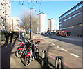
Bike Dock, Hampstead Road
Originally blue and sponsored by Barclays Bank, these hire cycles quickly acquired the name Boris Bikes thanks to Mayor Boris Johnson.
They are now red and white and sponsored by Santander Bank, so should Boris ever fall from grace Santa Bikes is a name in waiting.
Image: © Des Blenkinsopp
Taken: 2 Feb 2016
0.05 miles
10
Hampstead Road at the junction of Cardington Street
Image: © David Howard
Taken: 19 Jan 2017
0.05 miles