IMAGES TAKEN NEAR TO
Varndell Street, LONDON, NW1 3RR
Introduction
This page details the photographs taken nearby to Varndell Street, NW1 3RR by members of the Geograph project.
The Geograph project started in 2005 with the aim of publishing, organising and preserving representative images for every square kilometre of Great Britain, Ireland and the Isle of Man.

There are currently over 7.5m images from over14,400 individuals and you can help contribute to the project by visiting https://www.geograph.org.uk
Image Map
Images are licensed for reuse under creativecommons.org/licenses/by-sa/2.0
Notes
- Clicking on the map will re-center to the selected point.
- The higher the marker number, the further away the image location is from the centre of the postcode.
Image Listing (586 Images Found)
Images are licensed for reuse under creativecommons.org/licenses/by-sa/2.0
Image
Details
Distance
1
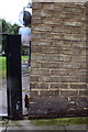
Benchmark on 'The Tarns', Varndell Street
Ordnance Survey cut mark benchmark described on the Bench Mark Database at http://www.bench-marks.org.uk/bm39280
Image: © Roger Templeman
Taken: 20 Aug 2011
0.00 miles
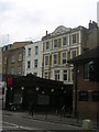
2
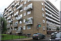
'The Tarns', Varndell Street
There is an OS benchmark Image near the corner of the building
Image: © Roger Templeman
Taken: 20 Aug 2011
0.00 miles
3

Camden Recycling Centre
Refuse bins to you and me, but with a serious purpose.
Image: © kim traynor
Taken: 16 Jul 2010
0.02 miles
4
Hampstead Road at the junction of Cardington Street
Image: © David Howard
Taken: 19 Jan 2017
0.02 miles
6
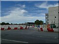
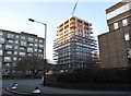
Entrance to HS2 construction site, Hampstead Road
Roughly on the site of the former Thistle Hotel Image which has been demolished alongside several other buildings and a graveyard to make way for the new high-speed rail terminus at Euston.
Image: © Stephen Craven
Taken: 28 Jun 2022
0.03 miles
7
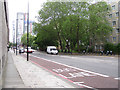
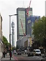
South on Hampstead Road NW1
Medium-rise public housing on the right. The Euston Tower and the BT Tower beyond it on the left.
Image: © Robin Stott
Taken: 8 Jun 2012
0.03 miles
8
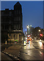
Hampstead Road
At the junction with Cardington Street, with the long-closed National Temperance Hospital behind the cyclist.
Image: © Hugh Venables
Taken: 13 Oct 2014
0.03 miles
9
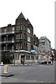
National Temperance Hospital
Built in 1885, the hospital has been closed since 2002. Sheila Madhvani's Image gives a different angle and fuller historical details.
Image: © Martin Addison
Taken: 30 Dec 2011
0.04 miles
10
The Prince of Wales, Hampstead Road, NW1
As so often, the commercial premises along this road occupying 19th-century terraces have obviously been built on top of what were once gardens.
Image: © Christopher Hilton
Taken: 9 May 2006
0.04 miles