IMAGES TAKEN NEAR TO
Stanhope Street, LONDON, NW1 3JX
Introduction
This page details the photographs taken nearby to Stanhope Street, NW1 3JX by members of the Geograph project.
The Geograph project started in 2005 with the aim of publishing, organising and preserving representative images for every square kilometre of Great Britain, Ireland and the Isle of Man.

There are currently over 7.5m images from over14,400 individuals and you can help contribute to the project by visiting https://www.geograph.org.uk
Image Map
Images are licensed for reuse under creativecommons.org/licenses/by-sa/2.0
Notes
- Clicking on the map will re-center to the selected point.
- The higher the marker number, the further away the image location is from the centre of the postcode.
Image Listing (720 Images Found)
Images are licensed for reuse under creativecommons.org/licenses/by-sa/2.0
Image
Details
Distance
1
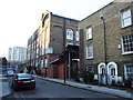
Primary School, Netley Street, Camden
Image: © Chris Whippet
Taken: 26 Dec 2008
0.02 miles
2
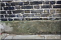
Benchmark on wall of Netley Street
Ordnance Survey cut mark benchmark described on the Bench Mark Database at http://www.bench-marks.org.uk/bm39277
Image: © Roger Templeman
Taken: 20 Aug 2011
0.02 miles
3
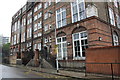
Netley Street School
There is an OS benchmark Image on the wall past the far end of the school
Image: © Roger Templeman
Taken: 20 Aug 2011
0.02 miles
4
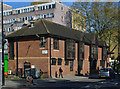
Euston area - 9 April 2014 (5)
On the Hampstead Road at the corner of Prince of Wales Passage, the former Prince of Wales public house now trades as Shaker & Co.
Photograph is for record only - I have no connection with this business.
Image: © The Carlisle Kid
Taken: 9 Apr 2014
0.02 miles
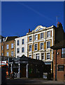
5
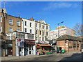
The Prince is now Shaking
The building centre shot has the Prince of Wales feathers moulded on the parapet, and the old pub name set in stone below the top windows.
Down below there's still a bar, but now trading as Shaker & Company.
Hampstead Road, NW1.
Image: © Des Blenkinsopp
Taken: 2 Feb 2016
0.03 miles
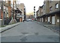
7
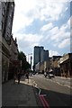
Hampstead Road
With BT Tower evident in the distance.
Image: © DS Pugh
Taken: 24 Jul 2014
0.03 miles
8
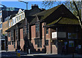
Euston area - 9 April 2014 (3)
Bengali Workers' Association, Surma Community Centre (1). On the Hampstead Road between Robert Street and Prince of Wales Passage.
Photograph is for record only - I have no connection with this organisation.
Image: © The Carlisle Kid
Taken: 9 Apr 2014
0.04 miles
9
Euston area - 9 April 2014 (4)
Bengali Workers' Association, Surma Community Centre (2). On the Hampstead Road at the corner of Robert Street and Prince of Wales Passage.
Photograph is for record only - I have no connection with this organisation.
Image: © The Carlisle Kid
Taken: 9 Apr 2014
0.04 miles
10
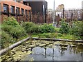
Netley Primary School, Garden pond
Our new garden pond. It has recently attracted mating pairs of mallards.
Image: © P KAVANAGH
Taken: 28 Apr 2016
0.04 miles