IMAGES TAKEN NEAR TO
Charrington Street, LONDON, NW1 1RS
Introduction
This page details the photographs taken nearby to Charrington Street, NW1 1RS by members of the Geograph project.
The Geograph project started in 2005 with the aim of publishing, organising and preserving representative images for every square kilometre of Great Britain, Ireland and the Isle of Man.

There are currently over 7.5m images from over14,400 individuals and you can help contribute to the project by visiting https://www.geograph.org.uk
Image Map
Images are licensed for reuse under creativecommons.org/licenses/by-sa/2.0
Notes
- Clicking on the map will re-center to the selected point.
- The higher the marker number, the further away the image location is from the centre of the postcode.
Image Listing (745 Images Found)
Images are licensed for reuse under creativecommons.org/licenses/by-sa/2.0
Image
Details
Distance
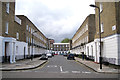
2
Iceberg on Platt Street, NW1
The white-flowered Floribunda rose flops over a railing to engage passers-by. In the background is the block of flats called The Chenies.
Image: © Robin Stott
Taken: 8 Jun 2012
0.03 miles
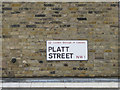
3
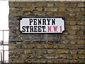
Street nameplate mounted on London brick
Surprising survival: a cast metal (probably cast iron) nameplate in an older style. The little quadrants cut out of the corners are somehow in keeping with the style of typeface, a condensed Egyptian: Egyptian and Tuscan faces are characterised by slab serifs.
Image: © Robin Stott
Taken: 8 Jun 2012
0.03 miles
4
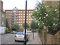
Oakshott Court Estate, Somers Town - 1
Oakshott Court is a 1970s housing development designed by Peter Tábori of the Camden Council Architect's Department. More at this http://manchesterhistory.net/architecture/1970/oakshott.html.
Image: © Jim Osley
Taken: 19 Jun 2016
0.03 miles
6
Street nameplate mounted on London brick
An enamelled steel or aluminium nameplate. Font: Transport, the standard type design for road signs. The widely-spaced letters aid quick recognition and easy reading. Transport was designed by Jock Kinneir and Margaret Calvert for the planned motorway network; the big blue and white signs were tested on the Preston Bypass, now part of the M6, and appeared on the first section of the M1 in 1959. Thereafter the font was adopted for signage on all UK roads and has been widely used in other countries.
Image: © Robin Stott
Taken: 8 Jun 2012
0.05 miles
7
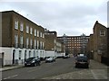
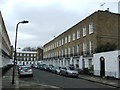
Penryn Street, NW1
A strikingly neat, uniform, treeless street of 3-storey houses in London brick. The view is north from Platt Street.
Image: © Robin Stott
Taken: 8 Jun 2012
0.06 miles
8
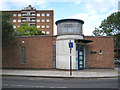
Entrance to Edith Neville Primary School
Image: © Stephen Craven
Taken: 28 Jun 2022
0.06 miles
9
Entrance, Doreen Bazell Hall, NW1
It is a small public hall on the corner of Chenies Place and Goldington Street. It may be hired from Camden Council. It has many different users. In the background here is he block of flats called The Chenies.
Image: © Robin Stott
Taken: 8 Jun 2012
0.06 miles
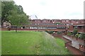
10
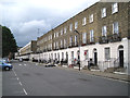
North end of Ossulston Street
A strikingly long terrace surviving in this much-redeveloped part of London.
Image: © Robin Stott
Taken: 8 Jun 2012
0.06 miles