IMAGES TAKEN NEAR TO
Phoenix Road, LONDON, NW1 1ER
Introduction
This page details the photographs taken nearby to Phoenix Road, NW1 1ER by members of the Geograph project.
The Geograph project started in 2005 with the aim of publishing, organising and preserving representative images for every square kilometre of Great Britain, Ireland and the Isle of Man.

There are currently over 7.5m images from over14,400 individuals and you can help contribute to the project by visiting https://www.geograph.org.uk
Image Map (Loading...)


Getting Data...Please wait
Leaflet Map data © OpenStreetMap
Images are licensed for reuse under creativecommons.org/licenses/by-sa/2.0
Notes
- Clicking on the map will re-center to the selected point.
- The higher the marker number, the further away the image location is from the centre of the postcode.
Image Listing (913 Images Found)
Images are licensed for reuse under creativecommons.org/licenses/by-sa/2.0
Image
Details
Distance
1
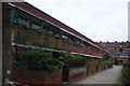
View of blocks of flats on Werrington Street #2
Looking north-northeast.
Image: © Robert Lamb
Taken: 12 Jan 2019
0.01 miles
2
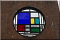
View of a colourful window on the side of Somers Town Children's Centre
Looking north-northwest from Polygon Road.
Image: © Robert Lamb
Taken: 12 Jan 2019
0.02 miles
3
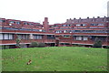
View of blocks of flats on Werrington Street and Phoenix Road #2
Looking north-northeast.
Image: © Robert Lamb
Taken: 12 Jan 2019
0.02 miles
4
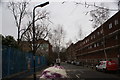
View along Polygon Road
Looking north-northeast.
Image: © Robert Lamb
Taken: 12 Jan 2019
0.02 miles
5
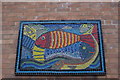
View of a mosaic of a fish on the wall of Somers Town Children's Centre
Looking north-northwest from Polygon Road.
Image: © Robert Lamb
Taken: 12 Jan 2019
0.02 miles
6
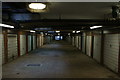
View along the garage block in the block of flats on Werrington Street
Looking north-northeast.
Image: © Robert Lamb
Taken: 12 Jan 2019
0.02 miles
7
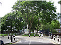
North end of Ossulston Street, NW1
Between a school and a playground the street appears to have been closed and planted with trees. There is only a pedestrian and cycle way through from Charrington Street to the north. Polygon Road crosses Ossulston Street here.
Image: © Robin Stott
Taken: 8 Jun 2012
0.03 miles
8
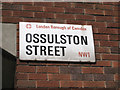
Street nameplate mounted on dark red brick
As in Chenies Place Image this enamelled metal plate stands proud of the wall. It appears to be edge-fixed to a concealed wall-mounted baseplate: note the staining.
Here all the writing is in one family of typefaces: Univers; the bespoke 'Camden' seen elsewhere is here written out as the council's name in full. Univers (French pronunciation: üni-vair) was designed by Adrian Frutiger in 1954 for the type founder Deberny & Peignot. It is renowned for its clarity and legibility, comes in many styles and has found many uses worldwide. http://en.wikipedia.org/wiki/Univers
Image: © Robin Stott
Taken: 8 Jun 2012
0.03 miles
9
Entrance to Edith Neville Primary School
Image: © Stephen Craven
Taken: 28 Jun 2022
0.03 miles
10
View of blocks of flats on Werrington Street
Looking south-southwest.
Image: © Robert Lamb
Taken: 12 Jan 2019
0.04 miles