IMAGES TAKEN NEAR TO
Brownlow Road, LONDON, NW10 9QS
Introduction
This page details the photographs taken nearby to Brownlow Road, NW10 9QS by members of the Geograph project.
The Geograph project started in 2005 with the aim of publishing, organising and preserving representative images for every square kilometre of Great Britain, Ireland and the Isle of Man.

There are currently over 7.5m images from over14,400 individuals and you can help contribute to the project by visiting https://www.geograph.org.uk
Image Map (Loading...)


Getting Data...Please wait
Leaflet Map data © OpenStreetMap
Images are licensed for reuse under creativecommons.org/licenses/by-sa/2.0
Notes
- Clicking on the map will re-center to the selected point.
- The higher the marker number, the further away the image location is from the centre of the postcode.
Image Listing (120 Images Found)
Images are licensed for reuse under creativecommons.org/licenses/by-sa/2.0
Image
Details
Distance
1
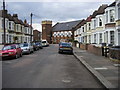
West Ella Road
West Ella Road looking to Church on corner of Church Road
Image: © Shaun Ferguson
Taken: 27 Mar 2009
0.03 miles
2
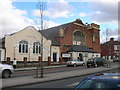
Restoration Revival Fellowship Apostolic Church, Church Road NW10
At the junction of West Ella Road, NW10 (southern junction).
Image: © Robin Sones
Taken: 27 Mar 2009
0.05 miles
4
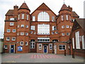
Willesden: St Joseph's Roman Catholic Primary School (1)
High up in the terracotta gable end is the carved date 1896 and the initials WSB which the photographer is guessing stand for Willesden School Board. As with many schools of this age it has had a chequered history. It probably started off as Leopold Road School to serve the streets of new Victorian housing that were being built in the area at that time, but later may have become a Secondary Modern School before reverting back to the current junior school. This is the original Leopold Road frontage with its pair of attractive 4-storey octagonal turrets, the symmetry of which is spoiled by the modern ground floor entrance extensions. The School's formal address is now in Goodson Road Image which is around to the right in this photograph.
Image: © Nigel Cox
Taken: 26 Sep 2010
0.06 miles
5
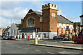
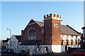
Restoration Revival Fellowship - Apostolic Church
This started out as a Congregational Church and seems to have been built around Edwardian times.
Image: © Robin Webster
Taken: 12 Feb 2011
0.07 miles
6
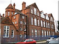
Willesden: St Joseph's Roman Catholic Primary School (2)
This is the Goodson Road frontage of Image
Image: © Nigel Cox
Taken: 26 Sep 2010
0.07 miles
7
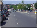
Church Road Harlesden
A407 looking north towards Neasden.
Image: © David Howard
Taken: 24 Jun 2009
0.08 miles
8
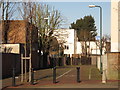
Path and cycle track north of Leopold Road, NW10
Image: © Mike Quinn
Taken: 15 Feb 2012
0.08 miles
10
Redfern Road, NW10 (3)
Shows the location of Image
Image: © Mike Quinn
Taken: 20 Dec 2011
0.08 miles