IMAGES TAKEN NEAR TO
Greenhill Park, LONDON, NW10 9AP
Introduction
This page details the photographs taken nearby to Greenhill Park, NW10 9AP by members of the Geograph project.
The Geograph project started in 2005 with the aim of publishing, organising and preserving representative images for every square kilometre of Great Britain, Ireland and the Isle of Man.

There are currently over 7.5m images from over14,400 individuals and you can help contribute to the project by visiting https://www.geograph.org.uk
Image Map
Images are licensed for reuse under creativecommons.org/licenses/by-sa/2.0
Notes
- Clicking on the map will re-center to the selected point.
- The higher the marker number, the further away the image location is from the centre of the postcode.
Image Listing (129 Images Found)
Images are licensed for reuse under creativecommons.org/licenses/by-sa/2.0
Image
Details
Distance
1
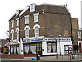
Bridge Food, Harlesden
A shop on Acton Lane at its junction with Minet Road.
Image: © Peter Whatley
Taken: 10 Apr 2011
0.06 miles
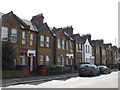
2
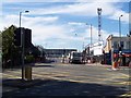
Acton Lane, Harlesden NW10
Junction with Mordaunt Road - Harlesden Station
Image: © Russell Trebor
Taken: 16 Jul 2006
0.06 miles
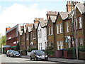
3
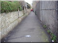
Footpath from Baker Road to Acton Lane
Image: © David Howard
Taken: 12 Mar 2009
0.10 miles
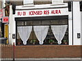
4
The New Atlas Cafe Restaurant on Harrow Road
Image: © David Howard
Taken: 21 Mar 2015
0.11 miles
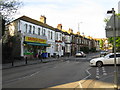
5
Harlesden
Nicoll Road. Harlesden NW10
Image: © Russell Trebor
Taken: 21 Apr 2017
0.12 miles
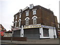
6
The New Atlas Cafe Restaurant, Craven Park Road (A404), NW10
Image: © Mike Quinn
Taken: 20 Dec 2011
0.13 miles
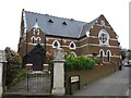
7
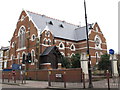
St. Margaret's & St. George's United Reformed & Moravian Church, Craven Park Road (A404), NW10
Image: © Mike Quinn
Taken: 20 Dec 2011
0.13 miles