IMAGES TAKEN NEAR TO
Kingfisher Way, LONDON, NW10 8TN
Introduction
This page details the photographs taken nearby to Kingfisher Way, NW10 8TN by members of the Geograph project.
The Geograph project started in 2005 with the aim of publishing, organising and preserving representative images for every square kilometre of Great Britain, Ireland and the Isle of Man.

There are currently over 7.5m images from over14,400 individuals and you can help contribute to the project by visiting https://www.geograph.org.uk
Image Map (Loading...)


Getting Data...Please wait
Leaflet Map data © OpenStreetMap
Images are licensed for reuse under creativecommons.org/licenses/by-sa/2.0
Notes
- Clicking on the map will re-center to the selected point.
- The higher the marker number, the further away the image location is from the centre of the postcode.
Image Listing (117 Images Found)
Images are licensed for reuse under creativecommons.org/licenses/by-sa/2.0
Image
Details
Distance
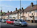
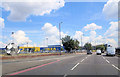
2
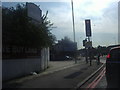
Houses on the North Circular
These terraced houses dating from the 1930's are on one of the busiest traffic routes in London. As can be seen this is a red route clearway with double red lines mean there is no stopping at any time.
Image: © Nigel Mykura
Taken: 24 Aug 2014
0.05 miles
3
Wembley: A406 North Circular Road
A GATSO speed camera, named after its inventor, one Maurice Gatsonides, stands outside IKEA in Wembley ready to record any vehicles exceeding the 40 mph speed limit. The Red Route Urban Clearway road marking, indicating that no stopping is allowed at any time, is also visible.
Image: © Nigel Cox
Taken: 9 Mar 2008
0.05 miles
4
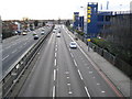
Wembley: A406 North Circular Road
The North Circular Road began life in the 1920s as development spread out through north-west London and it has always been the A406. However in the 1960s the Greater London Council proposed plans to construct a series of high-speed circular and radial motorways throughout London to ease traffic congestion. Under these plans the North Circular Road was designated to become the northern section of a circular route known as Ringway 2, being the second inner of the four proposed Ringways. It was planned that it would eventually be upgraded to a motorway, provisionally designated as the M15. These plans were cancelled in 1973.
This view was taken from the footbridge leading to IKEA and Tesco, with the IKEA store on the right.
Image: © Nigel Cox
Taken: 9 Mar 2008
0.05 miles
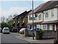
5
Lights at the junction of Brentfield Road and the North Circular
Image: © David Howard
Taken: 1 Sep 2011
0.06 miles
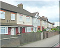
6
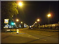
A406 - North Circular Road II, NW10
Junction with Drury Way and Brentfield Road.
Image: © Phillip Perry
Taken: 12 Nov 2008
0.06 miles
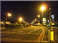
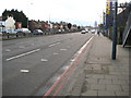
9
The North Circular at the junction of Brentfield Road
IKEA is just to the left of here
Image: © David Howard
Taken: 5 Aug 2014
0.08 miles