IMAGES TAKEN NEAR TO
Fig Tree Close, LONDON, NW10 8SW
Introduction
This page details the photographs taken nearby to Fig Tree Close, NW10 8SW by members of the Geograph project.
The Geograph project started in 2005 with the aim of publishing, organising and preserving representative images for every square kilometre of Great Britain, Ireland and the Isle of Man.

There are currently over 7.5m images from over14,400 individuals and you can help contribute to the project by visiting https://www.geograph.org.uk
Image Map (Loading...)


Getting Data...Please wait
Leaflet Map data © OpenStreetMap
Images are licensed for reuse under creativecommons.org/licenses/by-sa/2.0
Notes
- Clicking on the map will re-center to the selected point.
- The higher the marker number, the further away the image location is from the centre of the postcode.
Image Listing (111 Images Found)
Images are licensed for reuse under creativecommons.org/licenses/by-sa/2.0
Image
Details
Distance
1
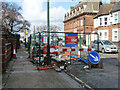
Road up, Church Road, Harlesden
Thames Water, using contractor Optimise.
Image: © Robin Webster
Taken: 12 Feb 2011
0.03 miles
3
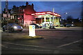
Total Energies on Church Road, Harlesden
This used to be Jet and is now a brand I've never come across before.
Image: © David Howard
Taken: 31 Jan 2023
0.05 miles
4
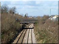
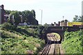
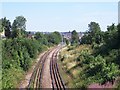
Bridge over Dudding Hill line
The normally freight only line (no scheduled passenger services) is crossed by Craven Park.
Image: © Robin Webster
Taken: 12 Feb 2011
0.06 miles
6
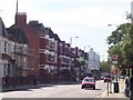
Craven Park NW10
Looking towards Craven Park Road from opposite Harlesden Police Station
Image: © Russell Trebor
Taken: 16 Jul 2006
0.06 miles
8
Looking down Church Road NW10 at the junction with West Ella Road, NW10
Taken from Craven Park, NW10
Image: © Robin Sones
Taken: 27 Mar 2009
0.06 miles
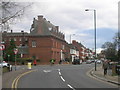
10
West Point NW10
Junction of Craven Park and Brentfield Road known locally as West Point
Image: © Russell Trebor
Taken: 16 Jul 2006
0.07 miles