IMAGES TAKEN NEAR TO
Craven Park, LONDON, NW10 8QN
Introduction
This page details the photographs taken nearby to Craven Park, NW10 8QN by members of the Geograph project.
The Geograph project started in 2005 with the aim of publishing, organising and preserving representative images for every square kilometre of Great Britain, Ireland and the Isle of Man.

There are currently over 7.5m images from over14,400 individuals and you can help contribute to the project by visiting https://www.geograph.org.uk
Image Map
Images are licensed for reuse under creativecommons.org/licenses/by-sa/2.0
Notes
- Clicking on the map will re-center to the selected point.
- The higher the marker number, the further away the image location is from the centre of the postcode.
Image Listing (103 Images Found)
Images are licensed for reuse under creativecommons.org/licenses/by-sa/2.0
Image
Details
Distance
1
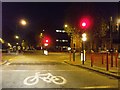
Brentfield Road, NW10
Junction of Brentside, Craven Park & Knatchbull Road.
Image: © Phillip Perry
Taken: 12 Nov 2008
0.02 miles
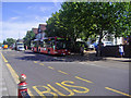
3
Brentfield Road/Harrow Road NW10
The ex Service Rendered Club (Alti Mara)
Image: © Russell Trebor
Taken: 16 Jul 2006
0.04 miles
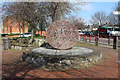
5
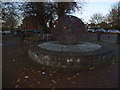
Public art on the corner of Brentfield Road
Image: © David Howard
Taken: 4 Dec 2013
0.04 miles
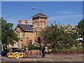
6
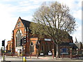
The Church of St. Michael and All Angels, Stonebridge
Image: © Mike Quinn
Taken: 20 Apr 2012
0.05 miles
8
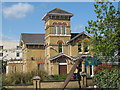
The Stonebridge Centre
Run by Brent's Adult and Community Education Service.
Image: © Mike Quinn
Taken: 20 Apr 2012
0.06 miles
9
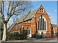
The Church of St. Michael and All Angels, Stonebridge (2)
Image: © Mike Quinn
Taken: 20 Apr 2012
0.06 miles
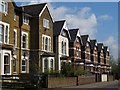
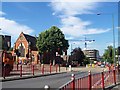
10
West Point NW10
Junction of Craven Park and Brentfield Road known locally as West Point
Image: © Russell Trebor
Taken: 16 Jul 2006
0.06 miles