IMAGES TAKEN NEAR TO
Elgar Avenue, LONDON, NW10 8PH
Introduction
This page details the photographs taken nearby to Elgar Avenue, NW10 8PH by members of the Geograph project.
The Geograph project started in 2005 with the aim of publishing, organising and preserving representative images for every square kilometre of Great Britain, Ireland and the Isle of Man.

There are currently over 7.5m images from over14,400 individuals and you can help contribute to the project by visiting https://www.geograph.org.uk
Image Map (Loading...)


Getting Data...Please wait
Leaflet Map data © OpenStreetMap
Images are licensed for reuse under creativecommons.org/licenses/by-sa/2.0
Notes
- Clicking on the map will re-center to the selected point.
- The higher the marker number, the further away the image location is from the centre of the postcode.
Image Listing (110 Images Found)
Images are licensed for reuse under creativecommons.org/licenses/by-sa/2.0
Image
Details
Distance
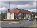
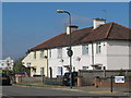
1
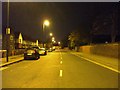
Brentfield Road, NW10
Looking towards the North Circular Road.
Image: © Phillip Perry
Taken: 12 Nov 2008
0.00 miles
2
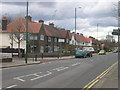
Brentfield Road, NW10 at Junction with Normansmead, NW10
Image: © Robin Sones
Taken: 27 Mar 2009
0.01 miles
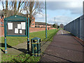
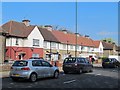
4
Neasden Footpath and Cyclepath from Meadow Gate, NW10
Looking across Brentfield Road, NW10 - the Swaminarayan School building can be seen on the right and one of the chimneys from Taylor's Lane Power Station.
Image: © Robin Sones
Taken: 27 Mar 2009
0.04 miles
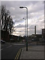
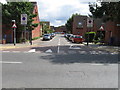
5
Meadow Garth, NW10 at junction with Brentfield Road, NW10
Image: © Robin Sones
Taken: 27 Mar 2009
0.04 miles
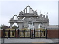
10
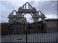
Gate to Neasden Temple, Brentfield Road
Image: © David Howard
Taken: 10 Jul 2008
0.06 miles