IMAGES TAKEN NEAR TO
Kingthorpe Road, LONDON, NW10 8JE
Introduction
This page details the photographs taken nearby to Kingthorpe Road, NW10 8JE by members of the Geograph project.
The Geograph project started in 2005 with the aim of publishing, organising and preserving representative images for every square kilometre of Great Britain, Ireland and the Isle of Man.

There are currently over 7.5m images from over14,400 individuals and you can help contribute to the project by visiting https://www.geograph.org.uk
Image Map (Loading...)


Getting Data...Please wait
Leaflet Map data © OpenStreetMap
Images are licensed for reuse under creativecommons.org/licenses/by-sa/2.0
Notes
- Clicking on the map will re-center to the selected point.
- The higher the marker number, the further away the image location is from the centre of the postcode.
Image Listing (104 Images Found)
Images are licensed for reuse under creativecommons.org/licenses/by-sa/2.0
Image
Details
Distance
2
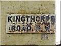
Sign for Kingthorpe Road, NW10
Image: © Mike Quinn
Taken: 20 Apr 2012
0.02 miles
5
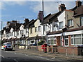
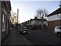
Kingthorpe Terrace, Brentfield Road, NW10 (2)
Image: © Mike Quinn
Taken: 20 Apr 2012
0.03 miles
8
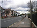
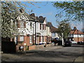
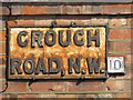
Brentfield Road, NW10 at junction with Crouch Road, NW10
Image: © Robin Sones
Taken: 27 Mar 2009
0.03 miles
9
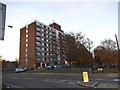
Block of flats on Gloucester Close, Stonebridge Park
Image: © David Howard
Taken: 4 Dec 2013
0.05 miles