IMAGES TAKEN NEAR TO
Fawood Avenue, LONDON, NW10 8HQ
Introduction
This page details the photographs taken nearby to Fawood Avenue, NW10 8HQ by members of the Geograph project.
The Geograph project started in 2005 with the aim of publishing, organising and preserving representative images for every square kilometre of Great Britain, Ireland and the Isle of Man.

There are currently over 7.5m images from over14,400 individuals and you can help contribute to the project by visiting https://www.geograph.org.uk
Image Map (Loading...)


Getting Data...Please wait
Leaflet Map data © OpenStreetMap
Images are licensed for reuse under creativecommons.org/licenses/by-sa/2.0
Notes
- Clicking on the map will re-center to the selected point.
- The higher the marker number, the further away the image location is from the centre of the postcode.
Image Listing (86 Images Found)
Images are licensed for reuse under creativecommons.org/licenses/by-sa/2.0
Image
Details
Distance
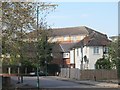
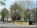
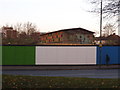
2
Stonebridge Park
I thought the Stonebridge Park estate was a modern high density council estate, but this is from the 1930s originally and the estate centre.
Image: © David Howard
Taken: 4 Dec 2013
0.11 miles
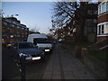
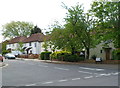
3
Stonebridge Park
This is the road giving its name to the entire area and station
Image: © David Howard
Taken: 4 Dec 2013
0.11 miles
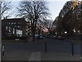
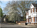
6
SW end of Meadow Garth, London NW10
Out of shot ahead, beyond the houses, is a footpath to Barry Road.
Image: © Jaggery
Taken: 13 May 2012
0.14 miles
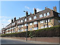
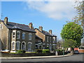
9
Fawood Children's Centre, Stonebridge Park
More new housing is presumably planned for these sites
Image: © David Howard
Taken: 4 Dec 2013
0.15 miles
10
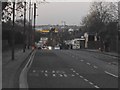
The view from Brentfield Road, Stonebridge Park
Looking towards the North Circular Road
Image: © David Howard
Taken: 4 Dec 2013
0.16 miles