IMAGES TAKEN NEAR TO
Harley Road, LONDON, NW10 8AY
Introduction
This page details the photographs taken nearby to Harley Road, NW10 8AY by members of the Geograph project.
The Geograph project started in 2005 with the aim of publishing, organising and preserving representative images for every square kilometre of Great Britain, Ireland and the Isle of Man.

There are currently over 7.5m images from over14,400 individuals and you can help contribute to the project by visiting https://www.geograph.org.uk
Image Map
Images are licensed for reuse under creativecommons.org/licenses/by-sa/2.0
Notes
- Clicking on the map will re-center to the selected point.
- The higher the marker number, the further away the image location is from the centre of the postcode.
Image Listing (175 Images Found)
Images are licensed for reuse under creativecommons.org/licenses/by-sa/2.0
Image
Details
Distance
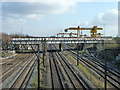
1
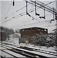
Small building by the West Coast Main line, Harlesden
Image: © N Chadwick
Taken: 19 Dec 2010
0.02 miles
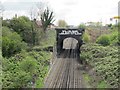
2
Harley Road, NW10
The red and white hoarding on the left of this photo with the stark message "Prepare To Meet Thy God" is seen by thousands of people each day -- the West Coast Mainline out of London Euston, and the Bakerloo Line run past here. The building it mounted on is the Harley Gospel Hall.
Image: © Danny P Robinson
Taken: 4 Feb 2007
0.04 miles
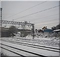
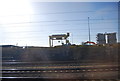
4
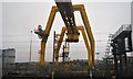
Railway over railway
The former Midland Dudding Hill Line, principally freight only, crosses over the main Euston line. A single track connection peels off to the right.
Image: © Robin Webster
Taken: 12 Feb 2011
0.06 miles
5
Bakerloo lines east of Harlesden station
See also Image
Image: © Mike Quinn
Taken: 20 Apr 2012
0.08 miles
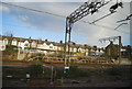
9

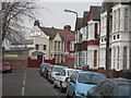
Harley Road, Harlesden, from the railway
On the extreme left, the gap in the houses indicates the junction with Fairlight Avenue.
Image: © Christopher Hilton
Taken: 24 Nov 2014
0.10 miles