IMAGES TAKEN NEAR TO
Abbey Road, LONDON, NW10 7BS
Introduction
This page details the photographs taken nearby to Abbey Road, NW10 7BS by members of the Geograph project.
The Geograph project started in 2005 with the aim of publishing, organising and preserving representative images for every square kilometre of Great Britain, Ireland and the Isle of Man.

There are currently over 7.5m images from over14,400 individuals and you can help contribute to the project by visiting https://www.geograph.org.uk
Image Map (Loading...)


Getting Data...Please wait
Leaflet Map data © OpenStreetMap
Images are licensed for reuse under creativecommons.org/licenses/by-sa/2.0
Notes
- Clicking on the map will re-center to the selected point.
- The higher the marker number, the further away the image location is from the centre of the postcode.
Image Listing (52 Images Found)
Images are licensed for reuse under creativecommons.org/licenses/by-sa/2.0
Image
Details
Distance

6
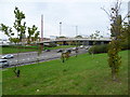
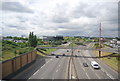
The former Twyford Tip and the North Circular Road
This was once part of Twyford Tip, also known as Abbey Road Mounds. Twyford Tip was a large irregular tip of waste material rising up to the south of the North Circular Road between Stonebridge and Hanger Lane. When the North Circular Road was widened in the 1990s,the mounds were re-moulded and landscaped. Here was where the eastern mound was located.
Image: © Marathon
Taken: 22 Oct 2014
0.13 miles

8
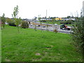
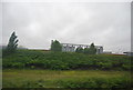
The former Twyford Tip and the North Circular Road
This was once part of Twyford Tip, also known as Abbey Road Mounds. Twyford Tip was a large irregular tip of waste material rising up to the south of the North Circular Road between Stonebridge and Hanger Lane. When the North Circular Road was widened in the 1990s,the mounds were re-moulded and landscaped. Here was where the eastern mound was located.
Image: © Marathon
Taken: 22 Oct 2014
0.14 miles