IMAGES TAKEN NEAR TO
Stephenson Street, LONDON, NW10 6TX
Introduction
This page details the photographs taken nearby to Stephenson Street, NW10 6TX by members of the Geograph project.
The Geograph project started in 2005 with the aim of publishing, organising and preserving representative images for every square kilometre of Great Britain, Ireland and the Isle of Man.

There are currently over 7.5m images from over14,400 individuals and you can help contribute to the project by visiting https://www.geograph.org.uk
Image Map
Images are licensed for reuse under creativecommons.org/licenses/by-sa/2.0
Notes
- Clicking on the map will re-center to the selected point.
- The higher the marker number, the further away the image location is from the centre of the postcode.
Image Listing (318 Images Found)
Images are licensed for reuse under creativecommons.org/licenses/by-sa/2.0
Image
Details
Distance
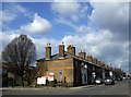
1

Goodhall Street, Park Royal
These were probably railway cottages going by a nearby sign.
Image: © David Howard
Taken: 31 Jan 2023
0.02 miles

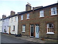
3
Railway Cottages, Old Oak Lane
Railway Cottages is the name of the terrace but they were actually railway workers' cottages. The area was owned and developed by the LNWR for their labour force.
The survival of Old Oak Lane Estate in more or less its original form as a planned workers' development is a rarity. Few examples exist in London, partly due to destruction of rail lines and yards by enemy action in WW2 but even more so because of postwar slum clearance and redevelopment. The area thus constitutes a significant piece of social history now part of the Old Oak Lane Conservation Area.
Image: © Natasha Ceridwen de Chroustchoff
Taken: 14 Mar 2010
0.04 miles
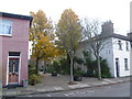
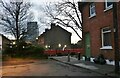
4
Railway workers' cottages in Harlesden
The London to Birmingham Railway was opened through Harlesden in 1837. The LNWR opened a large locomotive depot on a site on the south side of the main line to the west of Willesden Junction in 1873. Only then did the area become a focus of local activity. In the 19th century cottages for railway and industrial workers were built. The locomotive depot was enlarged in 1898. The London Midland & Scottish Railway opened an additional roundhouse on the site in 1929. Both buildings were demolished when the depot was closed in 1965 by British Railways and replaced by a Freightliner depot.
These railway workers' cottages from the second half of the 19th century are now an attractive little enclave on either side of Old Oak Lane, and between the West Coast Main Line, the Paddington Arm of the Grand Union Canal and the London Overground line between Willesden Junction and Acton Central. Names like Stephenson Street, Stoke Place and Crewe Place hint at their origins.
This view looks towards Goodhall Street from Old Oak Lane.
Image: © Marathon
Taken: 4 Dec 2013
0.04 miles
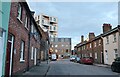
5
Goodhall Street, Harlesden
The London to Birmingham Railway was opened through Harlesden in 1837. The LNWR opened a large locomotive depot on a site on the south side of the main line to the west of Willesden Junction in 1873. Only then did the area become a focus of local activity. In the 19th century cottages for railway and industrial workers were built. The locomotive depot was enlarged in 1898. The London Midland & Scottish Railway opened an additional roundhouse on the site in 1929. Both buildings were demolished when the depot was closed in 1965 by British Railways and replaced by a Freightliner depot.
These railway workers' cottages from the second half of the 19th century are now, as can be seen here, an attractive little enclave on either side of Old Oak Lane, and between the West Coast Main Line, the Paddington Arm of the Grand Union Canal and the London Overground line between Willesden Junction and Acton Central. Names like Stephenson Street, Stoke Place and Crewe Place hint at their origins.
This view looks across one of the few stretches of Goodhall Street free from parked cars.
Image: © Marathon
Taken: 4 Dec 2013
0.04 miles
6
Goodhall Street, Harlesden
The London to Birmingham Railway was opened through Harlesden in 1837. The LNWR opened a large locomotive depot on a site on the south side of the main line to the west of Willesden Junction in 1873. Only then did the area become a focus of local activity. In the 19th century cottages for railway and industrial workers were built. The locomotive depot was enlarged in 1898. The London Midland & Scottish Railway opened an additional roundhouse on the site in 1929. Both buildings were demolished when the depot was closed in 1965 by British Railways and replaced by a Freightliner depot.
These railway workers' cottages from the second half of the 19th century are now, as can be seen here, an attractive little enclave on either side of Old Oak Lane, and between the West Coast Main Line, the Paddington Arm of the Grand Union Canal and the London Overground line between Willesden Junction and Acton Central. Names like Stephenson Street, Stoke Place and Crewe Place hint at their origins.
This view looks across Goodhall Street to a car free street leading to Old Oak Lane.
Image: © Marathon
Taken: 4 Dec 2013
0.04 miles
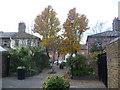
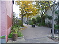
7

Path from Goodhall Street to Old Oak Lane
Image: © David Howard
Taken: 31 Jan 2023
0.04 miles
8
View from Goodhall Street, Harlesden
The London to Birmingham Railway was opened through Harlesden in 1837. The LNWR opened a large locomotive depot on a site on the south side of the main line to the west of Willesden Junction in 1873. Only then did the area become a focus of local activity. In the 19th century cottages for railway and industrial workers were built. The locomotive depot was enlarged in 1898. The London Midland & Scottish Railway opened an additional roundhouse on the site in 1929. Both buildings were demolished when the depot was closed in 1965 by British Railways and replaced by a Freightliner depot.
These railway workers' cottages from the second half of the 19th century are now, as can be seen here, an attractive little enclave on either side of Old Oak Lane, and between the West Coast Main Line, the Paddington Arm of the Grand Union Canal and the London Overground line between Willesden Junction and Acton Central. Names like Stephenson Street, Stoke Place and Crewe Place hint at their origins.
This view looks from Goodhall Street along a car free street leading to Old Oak Lane.
Image: © Marathon
Taken: 4 Dec 2013
0.05 miles
9
Goodhall Street, Park Royal
Goodhall Street is divided by Channel Gate Road which is an industrial estate. It can be seen continuing beyond the barrier.
Image: © David Howard
Taken: 31 Jan 2023
0.05 miles
10
Goodhall Street, Park Royal
The road signs say Park Royal so it starts here.
Image: © David Howard
Taken: 31 Jan 2023
0.05 miles