IMAGES TAKEN NEAR TO
St. Leonards Road, LONDON, NW10 6SX
Introduction
This page details the photographs taken nearby to St. Leonards Road, NW10 6SX by members of the Geograph project.
The Geograph project started in 2005 with the aim of publishing, organising and preserving representative images for every square kilometre of Great Britain, Ireland and the Isle of Man.

There are currently over 7.5m images from over14,400 individuals and you can help contribute to the project by visiting https://www.geograph.org.uk
Image Map (Loading...)


Getting Data...Please wait
Leaflet Map data © OpenStreetMap
Images are licensed for reuse under creativecommons.org/licenses/by-sa/2.0
Notes
- Clicking on the map will re-center to the selected point.
- The higher the marker number, the further away the image location is from the centre of the postcode.
Image Listing (127 Images Found)
Images are licensed for reuse under creativecommons.org/licenses/by-sa/2.0
Image
Details
Distance
1
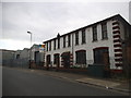
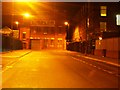
Old and new offices on St Leonards Road
Image: © David Howard
Taken: 13 Jun 2015
0.05 miles
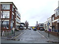
2
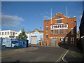
North Acton: The Old Torpedo Factory
Unlikely though it may seem this building in St Leonard's Road does appear to have been a torpedo factory at some time, possibly built during the First World War in what was then a fairly isolated location, where the damage to life and property that would be caused by an accidental explosion would be minimized. However that said there are no positive clues currently on the internet, and, given its apparent past use, it surprisingly does not appear to be a locally listed building either.
Image: © Nigel Cox
Taken: 26 Sep 2010
0.08 miles
4
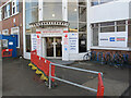
Braitrim House as HS2 construction site office
Braitrim House was an office for Braiform, then became serviced office space, and is shown here as office for Skanska Costain Strabag Joint Venture (SCSJV) contractor for HS2 Main Works Civils (MWC) South Route, major works preparing for the section of HS2 from Northolt to Euston.
In the time of coronavirus, note the signs to "Stop the spread" and "Clean your hands".
Image: © David Hawgood
Taken: 23 Feb 2021
0.10 miles
5
Chandos Road, NW10
Part of the large industrial area known as Park Royal, this road during the day would be busy.
Image: © Phillip Perry
Taken: 1 Oct 2008
0.10 miles
6
School Road, North Acton
School Road in North Acton. This street is characterised by business and light industrial buildings.
Image: © Malc McDonald
Taken: 28 Dec 2012
0.10 miles
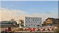
7
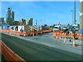
HS2 Victoria Road Crossover Box works, School Road
This is the junction of Victoria Road and (seen opposite) School Road, which is the Northern margin of this construction site.
Image: © David Hawgood
Taken: 12 Feb 2021
0.11 miles
8
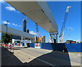
View under conveyor bridge to cranes and towers
These conveyors will take spoil from the HS2 crossover box and tunnels across Victoria Road to empty into a conveyor running north to Willesden freight yards. Photo across Victoria Road to cranes in the HS2 crossover box site and residential towers near North Acton station.
Image: © David Hawgood
Taken: 20 Jun 2022
0.11 miles
9
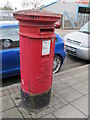
Edward VII postbox, Chase Road / Gorst Road, NW10
Image: © Mike Quinn
Taken: 20 Apr 2012
0.11 miles
10
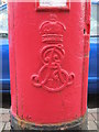
Edward VII postbox, Chase Road / Gorst Road, NW10 - royal cipher
See Image
Image: © Mike Quinn
Taken: 20 Apr 2012
0.11 miles