IMAGES TAKEN NEAR TO
Chandos Road, LONDON, NW10 6NF
Introduction
This page details the photographs taken nearby to Chandos Road, NW10 6NF by members of the Geograph project.
The Geograph project started in 2005 with the aim of publishing, organising and preserving representative images for every square kilometre of Great Britain, Ireland and the Isle of Man.

There are currently over 7.5m images from over14,400 individuals and you can help contribute to the project by visiting https://www.geograph.org.uk
Image Map
Images are licensed for reuse under creativecommons.org/licenses/by-sa/2.0
Notes
- Clicking on the map will re-center to the selected point.
- The higher the marker number, the further away the image location is from the centre of the postcode.
Image Listing (89 Images Found)
Images are licensed for reuse under creativecommons.org/licenses/by-sa/2.0
Image
Details
Distance
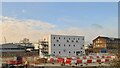
2

Chandos Road, NW10
Part of the large industrial area known as Park Royal, this road during the day would be busy.
Image: © Phillip Perry
Taken: 1 Oct 2008
0.06 miles
3

North Acton: The Old Torpedo Factory
Unlikely though it may seem this building in St Leonard's Road does appear to have been a torpedo factory at some time, possibly built during the First World War in what was then a fairly isolated location, where the damage to life and property that would be caused by an accidental explosion would be minimized. However that said there are no positive clues currently on the internet, and, given its apparent past use, it surprisingly does not appear to be a locally listed building either.
Image: © Nigel Cox
Taken: 26 Sep 2010
0.06 miles
4

Down freight on North & Southwestern line near Acton Wells Junction
View northward, towards Cricklewood (Brent Sidings): ex-N&SWJ line (Brent - Acton Wells). The locomotive is SR Bulleid's wartime Q1 class No. 33018 (built 4/42 as No. C18, withdrawn 7/65).
Image: © Ben Brooksbank
Taken: 23 Apr 1955
0.07 miles
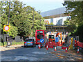
5

HS2 spoil conveyor enters Atlas Road site
The conveyor crosses both Victoria Road and London Overground railway on a bridge. It is shown here at the back of a car park heading from the bridge towards TQ21168297 in the Atlas Road site, then over the canal to Willesden rail yards.
Image: © David Hawgood
Taken: 3 Jan 2022
0.07 miles

7
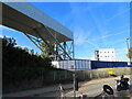
Site for conveyor transfer point, Victoria Road
The structure shown will carry the HS2 spoil conveyor over Victoria Road and London Overground. Plans show a bend in the conveyor system here, with a chute to transfer to a conveyor running close to London Overground within the Atlas Road site, over the canal, into the freight terminal. See also Image for another view and more details.
Image: © David Hawgood
Taken: 24 Oct 2021
0.08 miles
8
HS2 spoil conveyor, direction change point
Tunneling spoil will come on the bridge over road and railway, in these boxes will drop down and change direction slightly, to head to Willesden Freightliner terminal.
Image: © David Hawgood
Taken: 23 Feb 2022
0.08 miles

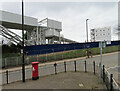
10
Bridge for HS2 spoil conveyor crosses road and railway
The conveyor is being built to move materials excavated for HS2 from Old Oak Common Station, Victoria Road Crossover Box and HS2 tunnels to Willesden Euroterminal. Here it crosses Victoria Road and London Overground.
Image: © David Hawgood
Taken: 24 Oct 2021
0.09 miles