1
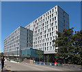
Abandoned Offices, Old Oak Lane
Windows broken and graffiti daubed liberally inside and out, these offices have been abandoned since circa 2004. A proposed new development called Nash House is currently going through the planning process and would see a larger building of similar height on the site providing a mix of office, business, retail, community and student accommodation.
Image: © Martin Addison
Taken: 1 Mar 2012
0.01 miles
2
North Acton: Nash House
Nash House is a former 1960s office building which has been unoccupied for several years and has fallen into a bad state of disrepair with broken windows, evidence of a fire on the upper floors, and with internal fittings strewn across the former car park. Plans have been submitted to demolish the existing building and replace it with a similar sized mixed use, but primarily student accommodation, building.
The 1893 Ordnance Survey map shows this to have been the site of the Willesden Paper & Canvas Works, while by the time that the 1935 Edition was published the same old paper works building was being described as Willesden Works (Brass Foundry).
Image: © Nigel Cox
Taken: 26 Sep 2010
0.01 miles
3
The Collective Old Oak- co-living apartment block
The block has over 500 apartments which have bedrooms and bathrooms, all other spaces including kitchens are shared, similar to student residences but aimed at people already working.
Image: © David Hawgood
Taken: 19 Jul 2016
0.01 miles
4
Security van parked on pavement, double yellow line and cycle lane
This van has been parked here for at least a month as a security office and dog kennel - it is beside a large derelict building, much vandalised. It belongs to a firm of law enforcement agents.
Image: © David Hawgood
Taken: 26 Mar 2012
0.01 miles
5
Cycle channel by steps from canal towpath
The steps lead from the towpath to Old Oak Lane by The Collective Old Oak - see
Image for a description of the building. The narrow ramp by the steps allow bicycles to access the road from the towpath. The trough may be called ed a wheeling ramp, push ramp or runnel.
Image: © David Hawgood
Taken: 19 Jul 2016
0.02 miles
6
Steps from canal towpath to The Collective Old Oak
See
Image for a description of this collective living apartment block.
Image: © David Hawgood
Taken: 19 Jul 2016
0.02 miles
7
Ramp to towpath from Old Oak Lane, Bridge 7 Paddington Arm
The slope is about 7 degrees, about 1 in 8, down to the towpath, with a section of about a yard at 1 in 7.
Image: © David Hawgood
Taken: 15 Dec 2011
0.03 miles
8
Old Oak Lane Bridge
Image: © N Chadwick
Taken: 9 Nov 2013
0.03 miles
9
Canal bridge 7 (Old Oak Lane)
Image: © John Slater
Taken: 29 Feb 2016
0.03 miles
10
Harlesden, Bridge No 7
Carrying Old Oak Lane over Grand Union Canal (Paddington Branch).
Image: © Mike Faherty
Taken: 9 Apr 2016
0.03 miles


