IMAGES TAKEN NEAR TO
Radcliffe Avenue, LONDON, NW10 5XS
Introduction
This page details the photographs taken nearby to Radcliffe Avenue, NW10 5XS by members of the Geograph project.
The Geograph project started in 2005 with the aim of publishing, organising and preserving representative images for every square kilometre of Great Britain, Ireland and the Isle of Man.

There are currently over 7.5m images from over14,400 individuals and you can help contribute to the project by visiting https://www.geograph.org.uk
Image Map
Images are licensed for reuse under creativecommons.org/licenses/by-sa/2.0
Notes
- Clicking on the map will re-center to the selected point.
- The higher the marker number, the further away the image location is from the centre of the postcode.
Image Listing (92 Images Found)
Images are licensed for reuse under creativecommons.org/licenses/by-sa/2.0
Image
Details
Distance
4
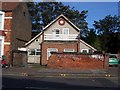
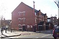
Small House - Park Parade NW10
Looks well out of place, might have started out as a garage/shed ?
Image: © Russell Trebor
Taken: 29 Oct 2006
0.09 miles
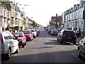
5
Park Parade NW10
Park Parade/Leghorn Road
Harlesden NW10
Flats built on ex St.Josephs School site
Image: © Russell Trebor
Taken: 3 Dec 2006
0.10 miles
6
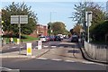
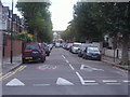
Harlesden Road NW10
Junction with Park Parade
Image: © Russell Trebor
Taken: 29 Oct 2006
0.10 miles
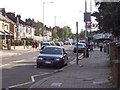
7
Park Parade, NW10 (2)
Shows the location of Image
Image: © Mike Quinn
Taken: 20 Dec 2011
0.10 miles
8
Rucklidge Ave, Harlesden NW10
Viewed from Park Parade End
Image: © Russell Trebor
Taken: 29 Oct 2006
0.11 miles
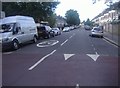
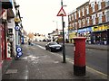
9
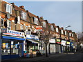
Shops and flats in Park Parade, NW10
East of Sellons Avenue.
Image: © Mike Quinn
Taken: 20 Dec 2011
0.11 miles
10
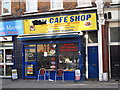
Cafe Shop, 69 Park Parade, NW10
The location of this café is shown in Image
Image: © Mike Quinn
Taken: 20 Dec 2011
0.12 miles