
IMAGES TAKEN NEAR TO
High Street, LONDON, NW10 4TD
Introduction
This page details the photographs taken nearby to High Street, NW10 4TD by members of the Geograph project.
The Geograph project started in 2005 with the aim of publishing, organising and preserving representative images for every square kilometre of Great Britain, Ireland and the Isle of Man.

There are currently over 7.5m images from over14,400 individuals and you can help contribute to the project by visiting https://www.geograph.org.uk
Image Map
Images are licensed for reuse under creativecommons.org/licenses/by-sa/2.0
Notes
- Clicking on the map will re-center to the selected point.
- The higher the marker number, the further away the image location is from the centre of the postcode.
Image Listing (210 Images Found)
Images are licensed for reuse under creativecommons.org/licenses/by-sa/2.0
Image
Details
Distance
1
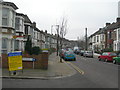
Tubbs Road, NW10
At the junction of Clifton Road. There was a shooting incident near here recently and the police are seeking more information.
Image: © Danny P Robinson
Taken: 4 Feb 2007
0.01 miles
3
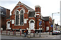
Church of God of Prophecy
Located on High Street Harlesden at the junction with Tubbs Road. The Church of God of Prophecy was founded in Tennessee and details of its history can be found on Wikipedia.
Image: © Martin Addison
Taken: 15 Feb 2012
0.03 miles
4
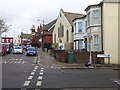
Tubbs Road/Clifton Road junction, Harlesden
Looking towards the Church of God of Prophecy; the cream building was the first Methodist chapel, followed by the red-brick structure beyond. Both were construction sites at the time of the photo
Image: © David Smith
Taken: 26 Nov 2015
0.03 miles
5
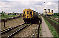
Departing Willesden Junction High Level
A 2-EPB unit (6315) leaves on its way to North Woolwich. Brought in to replace the ageing class 501 units in 1985, the two car 2-EPB's were too small for the volume of traffic and were subsequently replaced by three car class 313's.
The path in the centre of the photo connects Harrow Road with Willesden Junction station. The High Level part of the station is visible on the left of the photo whilst the awning of the Low Level station is visible on the right behind the footpath fence. Also on the right are the three cooling towers of Acton Lane Power Station which had closed in October 1983 - the station and its cooling towers were subsequently demolished.
Image: © Martin Addison
Taken: Unknown
0.03 miles
6
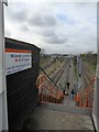
Footpath to Willesden Junction underground station
A long walk between the tracks to the station, avoiding the longer walk around the houses to Old Oak and Station Approach
Image: © David Smith
Taken: 26 Nov 2015
0.03 miles
7
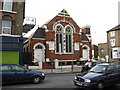
Church of God of Prophecy, Harlesden High Street
One wonders what particular set of myths are believed here, however, they have kept the building in an attractive state.
Image: © Dr Neil Clifton
Taken: 12 Feb 2009
0.03 miles
8
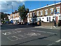
High Street Harlesden
At the junction with Tubbs Road.
Image: © David Martin
Taken: 18 Sep 2012
0.04 miles
9
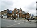
Harlesden, Church of God of Prophecy
Evangelical church on High Street.
Image: © Mike Faherty
Taken: 16 Apr 2016
0.04 miles
10
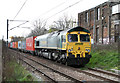
Cross London Containers
Freightliner Class 66, 66565, stands on the Harlesden Junction to Kensal Green Junction line awaiting its path between the passenger services on the North London Line. The train is the 4L57 Daventry International Rail Freight Terminal to Tilbury Rail Container Terminal.
Image: © Martin Addison
Taken: 19 Apr 2013
0.04 miles