IMAGES TAKEN NEAR TO
Cross Way, LONDON, NW10 3RF
Introduction
This page details the photographs taken nearby to Cross Way, NW10 3RF by members of the Geograph project.
The Geograph project started in 2005 with the aim of publishing, organising and preserving representative images for every square kilometre of Great Britain, Ireland and the Isle of Man.

There are currently over 7.5m images from over14,400 individuals and you can help contribute to the project by visiting https://www.geograph.org.uk
Image Map (Loading...)


Getting Data...Please wait
Leaflet Map data © OpenStreetMap
Images are licensed for reuse under creativecommons.org/licenses/by-sa/2.0
Notes
- Clicking on the map will re-center to the selected point.
- The higher the marker number, the further away the image location is from the centre of the postcode.
Image Listing (57 Images Found)
Images are licensed for reuse under creativecommons.org/licenses/by-sa/2.0
Image
Details
Distance
2
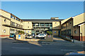
Willesden Centre for Health and Care
On Robson Avenue.
Image: © Robin Webster
Taken: 19 Mar 2011
0.04 miles
3
Willesden Centre for Health and Care
On Robson Avenue.
Image: © Robin Webster
Taken: 19 Mar 2011
0.04 miles
4
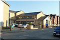
Robson Avenue, Willesden
Outside the health centre.
Image: © David Howard
Taken: 28 Apr 2022
0.05 miles
5
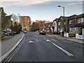
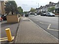
Robson Avenue looking south near the Willesden Centre for Health and Care
Image: © Tom Page
Taken: 20 Jan 2022
0.05 miles
6
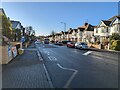
Flats on the corner of Donnington Road, Willesden
Image: © David Howard
Taken: 2 Dec 2021
0.06 miles
7
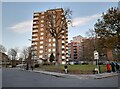
Tower block on the corner of Donnington Road and Harlesden Road
Image: © David Howard
Taken: 2 Dec 2021
0.07 miles
9
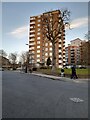
Donnington Road, Willesden
At the junction of Harlesden Road
Image: © David Howard
Taken: 2 Dec 2021
0.08 miles