IMAGES TAKEN NEAR TO
Leighton Gardens, LONDON, NW10 3PT
Introduction
This page details the photographs taken nearby to Leighton Gardens, NW10 3PT by members of the Geograph project.
The Geograph project started in 2005 with the aim of publishing, organising and preserving representative images for every square kilometre of Great Britain, Ireland and the Isle of Man.

There are currently over 7.5m images from over14,400 individuals and you can help contribute to the project by visiting https://www.geograph.org.uk
Image Map (Loading...)


Getting Data...Please wait
Leaflet Map data © OpenStreetMap
Images are licensed for reuse under creativecommons.org/licenses/by-sa/2.0
Notes
- Clicking on the map will re-center to the selected point.
- The higher the marker number, the further away the image location is from the centre of the postcode.
Image Listing (107 Images Found)
Images are licensed for reuse under creativecommons.org/licenses/by-sa/2.0
Image
Details
Distance
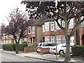
3
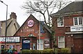
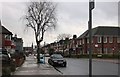
Hardinge Road at the junction of Chamberlayne Road
Image: © David Howard
Taken: 19 Dec 2019
0.05 miles
5
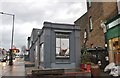
Cinema on Chamberlayne Road, Kensal Rise
Image: © David Howard
Taken: 19 Dec 2019
0.05 miles
6
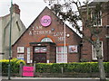
The Lexi Cinema, Chamberlayne Road, NW10
Further info about the cinema on its website http://thelexicinema.co.uk/.
Image: © Mike Quinn
Taken: 7 Sep 2011
0.06 miles
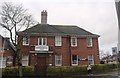
7
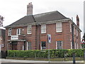
The Constitutional Club, Chamberlayne Road, NW10
Image: © Mike Quinn
Taken: 7 Sep 2011
0.06 miles
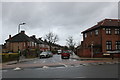
8
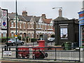
Chamberlayne Road / Okehampton Road, NW10 (2)
Shows the location of Image
Image: © Mike Quinn
Taken: 7 Sep 2011
0.06 miles
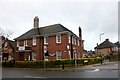
10
Alternative Bathrooms on Chamberlayne Road, Kensal Rise
Image: © David Howard
Taken: 19 Dec 2019
0.06 miles