IMAGES TAKEN NEAR TO
Denzil Road, LONDON, NW10 2UP
Introduction
This page details the photographs taken nearby to Denzil Road, NW10 2UP by members of the Geograph project.
The Geograph project started in 2005 with the aim of publishing, organising and preserving representative images for every square kilometre of Great Britain, Ireland and the Isle of Man.

There are currently over 7.5m images from over14,400 individuals and you can help contribute to the project by visiting https://www.geograph.org.uk
Image Map
Images are licensed for reuse under creativecommons.org/licenses/by-sa/2.0
Notes
- Clicking on the map will re-center to the selected point.
- The higher the marker number, the further away the image location is from the centre of the postcode.
Image Listing (178 Images Found)
Images are licensed for reuse under creativecommons.org/licenses/by-sa/2.0
Image
Details
Distance
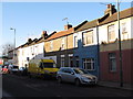
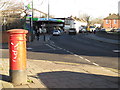
2
Neasden Lane, NW10 (2)
Just north of Denzil Road.
Image: © Mike Quinn
Taken: 15 Feb 2012
0.04 miles
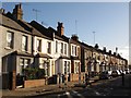
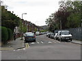
3
Houses on Neasden Lane
The goods line goes over the road on the left which is still in regular use going through Dudden Hill.
Image: © David Howard
Taken: 15 Apr 2015
0.05 miles
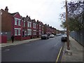
5
Neasden Lane, NW10 (4)
The west side, north of the junction with Wharton Close. Shows the location of Image
Image: © Mike Quinn
Taken: 15 Feb 2012
0.08 miles
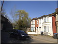
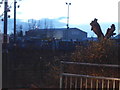
6
Willesden - Denzil Road
The arch of Wembley Stadium is just discernible in the distance.
Image: © Peter Whatley
Taken: 11 Apr 2011
0.09 miles
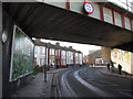
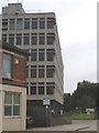
8
Warehouse by the Jubilee Line, Neasden
From the end of Southview Avenue
Image: © David Howard
Taken: 26 Dec 2013
0.09 miles
10
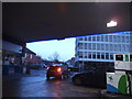
Harvest petrol station on Neasden Lane
Image: © David Howard
Taken: 26 Dec 2013
0.09 miles