IMAGES TAKEN NEAR TO
Kings Road, LONDON, NW10 2BL
Introduction
This page details the photographs taken nearby to Kings Road, NW10 2BL by members of the Geograph project.
The Geograph project started in 2005 with the aim of publishing, organising and preserving representative images for every square kilometre of Great Britain, Ireland and the Isle of Man.

There are currently over 7.5m images from over14,400 individuals and you can help contribute to the project by visiting https://www.geograph.org.uk
Image Map
Images are licensed for reuse under creativecommons.org/licenses/by-sa/2.0
Notes
- Clicking on the map will re-center to the selected point.
- The higher the marker number, the further away the image location is from the centre of the postcode.
Image Listing (168 Images Found)
Images are licensed for reuse under creativecommons.org/licenses/by-sa/2.0
Image
Details
Distance
6
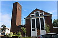
Harlesden Road, Willesden
Looking towards St Mary Magdalen Church
Image: © David Howard
Taken: 19 Dec 2019
0.06 miles
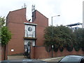
7
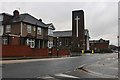
Willesden telephone exchange
This is the newest part, the original is on the right of here called Exchange House, fronting on St Andrew's Road.
Image: © David Howard
Taken: 2 Dec 2021
0.06 miles
9
Willesden telephone exchange
The original building is on the right of here.
Image: © David Howard
Taken: 2 Dec 2021
0.07 miles
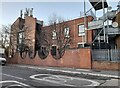
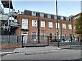
10
Willesden Telephone Exchange (2)
This photo, taken in Harlesden Road, shows the entrance to the TE which serves Church End and Willesden Green. This redbrick building shows the doors where the equipment is delivered from outside whilst there are mobile phone aerials in the U gap on the roof. A white BT notice can be seen on the lower wall, which would indicate that the building is a TE.
Image: © David Hillas
Taken: 5 Oct 2013
0.07 miles