IMAGES TAKEN NEAR TO
Parkfield Road, LONDON, NW10 2BJ
Introduction
This page details the photographs taken nearby to Parkfield Road, NW10 2BJ by members of the Geograph project.
The Geograph project started in 2005 with the aim of publishing, organising and preserving representative images for every square kilometre of Great Britain, Ireland and the Isle of Man.

There are currently over 7.5m images from over14,400 individuals and you can help contribute to the project by visiting https://www.geograph.org.uk
Image Map (Loading...)


Getting Data...Please wait
Leaflet Map data © OpenStreetMap
Images are licensed for reuse under creativecommons.org/licenses/by-sa/2.0
Notes
- Clicking on the map will re-center to the selected point.
- The higher the marker number, the further away the image location is from the centre of the postcode.
Image Listing (168 Images Found)
Images are licensed for reuse under creativecommons.org/licenses/by-sa/2.0
Image
Details
Distance
3
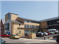
Willesden Centre for Health and Care
A new building replacing a community hospital
Image: © David Hawgood
Taken: 28 Jun 2005
0.04 miles
9
Harlesden Road, NW10 (5)
Shows the location of Image
Image: © Mike Quinn
Taken: 7 Sep 2011
0.06 miles
10
Harlesden Road, NW10 (4)
Shows the location of Image
Image: © Mike Quinn
Taken: 7 Sep 2011
0.06 miles