IMAGES TAKEN NEAR TO
Dobree Avenue, LONDON, NW10 2AD
Introduction
This page details the photographs taken nearby to Dobree Avenue, NW10 2AD by members of the Geograph project.
The Geograph project started in 2005 with the aim of publishing, organising and preserving representative images for every square kilometre of Great Britain, Ireland and the Isle of Man.

There are currently over 7.5m images from over14,400 individuals and you can help contribute to the project by visiting https://www.geograph.org.uk
Image Map
Images are licensed for reuse under creativecommons.org/licenses/by-sa/2.0
Notes
- Clicking on the map will re-center to the selected point.
- The higher the marker number, the further away the image location is from the centre of the postcode.
Image Listing (68 Images Found)
Images are licensed for reuse under creativecommons.org/licenses/by-sa/2.0
Image
Details
Distance
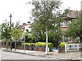
6
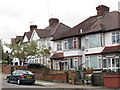
Houses on Donnington Road
Suburban housing with some added balconies overlooking the open space of Willesden Sports Centre.
Image: © Des Blenkinsopp
Taken: 20 Jan 2020
0.10 miles
8
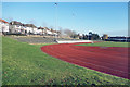
Athletics Track, Willesden Sports Centre
Image: © Des Blenkinsopp
Taken: 20 Jan 2020
0.12 miles
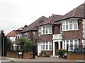
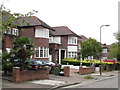
9
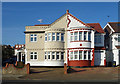
My Half, Your Half
Semi detached suburban neighbours with different tastes in exterior decor.
Image: © Des Blenkinsopp
Taken: 20 Jan 2020
0.14 miles