IMAGES TAKEN NEAR TO
Pendolino Way, LONDON, NW10 0RP
Introduction
This page details the photographs taken nearby to Pendolino Way, NW10 0RP by members of the Geograph project.
The Geograph project started in 2005 with the aim of publishing, organising and preserving representative images for every square kilometre of Great Britain, Ireland and the Isle of Man.

There are currently over 7.5m images from over14,400 individuals and you can help contribute to the project by visiting https://www.geograph.org.uk
Image Map (Loading...)


Getting Data...Please wait
Leaflet Map data © OpenStreetMap
Images are licensed for reuse under creativecommons.org/licenses/by-sa/2.0
Notes
- Clicking on the map will re-center to the selected point.
- The higher the marker number, the further away the image location is from the centre of the postcode.
Image Listing (115 Images Found)
Images are licensed for reuse under creativecommons.org/licenses/by-sa/2.0
Image
Details
Distance
1
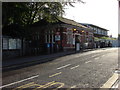
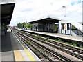
Stonebridge Park railway station, Tokyngton
Viewed across Argenta Way. The station is served by London Overground and London Underground trains. On the day of this view, a Sunday, there were no train services here because of nearby track engineering work. The ticket office was open. Replacement buses were providing shuttle services to the nearest open stations.
Image: © Jaggery
Taken: 13 May 2012
0.00 miles
2
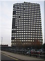
Stonebridge Park: Wembley Point
This prominent 21 storey office block rises to about 82 metres above ground level and is triangular in plan. It is a multiple occupancy building with its own website here http://www.wembleypointlondon.com/ It is just off the A406 North Circular Road and near to Stonebridge Park railway station on the Bakerloo Line.
Image: © Nigel Cox
Taken: 26 Nov 2007
0.01 miles
4
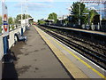
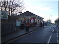
Stonebridge Park station, London Transport
The station is served by Bakerloo Line Underground trains, running between Harrow & Wealdstone and Elephant & Castle, and Overground services between Watford Junction and Euston.
Image: © Dr Neil Clifton
Taken: 26 Jun 2008
0.01 miles
5
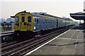
Class 501 at Stonebridge Park
This type of Electric Multiple Unit was the mainstay of services on the Euston to Watford and North London Line services from 1957 until 1985. Here we see two of the type, one in all over blue - the other in blue and grey livery, departing Stonebridge Park for Euston in September 1985. This was the last few weeks in service for the class, the last day of operation being 1st October 1985. Stonebridge Park station has been rebuilt since this photo was taken and the A406 North Circular Road has grown to an 8 lane dual carriageway at this point - where once it was single lane each side as it passed under the railway. Visible over the roof of the nearest unit is the Unisys building.
Image: © Martin Addison
Taken: Unknown
0.01 miles

9
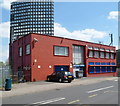
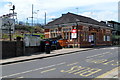
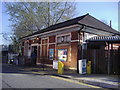
Argenta House, London NW10
Viewed across Argenta Way from outside Stonebridge Park railway station. http://www.geograph.org.uk/photo/3097678
Behind the 2-storey business premises (built in the 1960s) is Wembley Point office block. http://www.geograph.org.uk/photo/3097050
Image: © Jaggery
Taken: 13 May 2012
0.02 miles