IMAGES TAKEN NEAR TO
North Circular Road, LONDON, NW10 0JF
Introduction
This page details the photographs taken nearby to North Circular Road, NW10 0JF by members of the Geograph project.
The Geograph project started in 2005 with the aim of publishing, organising and preserving representative images for every square kilometre of Great Britain, Ireland and the Isle of Man.

There are currently over 7.5m images from over14,400 individuals and you can help contribute to the project by visiting https://www.geograph.org.uk
Image Map
Images are licensed for reuse under creativecommons.org/licenses/by-sa/2.0
Notes
- Clicking on the map will re-center to the selected point.
- The higher the marker number, the further away the image location is from the centre of the postcode.
Image Listing (135 Images Found)
Images are licensed for reuse under creativecommons.org/licenses/by-sa/2.0
Image
Details
Distance
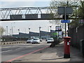
1
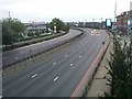
The North Circular Road, Neasden
From the footbridge
Image: © David Howard
Taken: 25 Jun 2017
0.02 miles
2
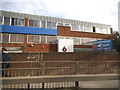
Offices on the North Circular Road, Neasden
Image: © David Howard
Taken: 9 Aug 2014
0.02 miles
3
A406 - North Circular Road, NW10
Taken from the footbridge next to Tesco & IKEA, to see the other side of the bridge which is in the next square: Image
Image: © Phillip Perry
Taken: 12 Nov 2008
0.02 miles
4
The North Circular Road in Neasden
IKEA is on the right out of shot
Image: © David Howard
Taken: 30 Aug 2014
0.02 miles
5
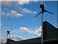
Wind turbines, Neasden
The wind turbines are two of a group of four on the roof of Datapoint House, 400 North Circular Road. Datapoint House is a development of mixed industrial and office units and the installation of wind turbines is part of the developers' bid to attain a high BREEAM (Buildings Research Establishment Environmental Assessment Method) rating for the building.
Image: © Cathy Cox
Taken: 9 Mar 2008
0.03 miles
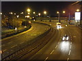
6
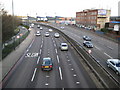
Neasden: A406 North Circular Road
The North Circular Road began life in the 1920s as development spread out through north-west London and it has always been the A406. However in the 1960s the Greater London Council proposed plans to construct a series of high-speed circular and radial motorways throughout London to ease traffic congestion. Under these plans the North Circular Road was designated to become the northern section of a circular route known as Ringway 2, being the second inner of the four proposed Ringways. It was planned that it would eventually be upgraded to a motorway, provisionally designated as the M15. These plans were cancelled in 1973.
In this view the 40mph speed restriction is enforced with cameras, while the new landmark of the four wind turbines at the Great Central Way exit is visible in the distance. Beacon House is to the right.
Another observation - of the 19 cars visible in this photo, 14 are silver, 4 are black, and the only one that appears to be different is the one in the foreground that appears to be a dark purple colour, a sign of changing preferences by the car-buying public.
Image: © Nigel Cox
Taken: 9 Mar 2008
0.04 miles
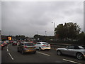
8
Tesco service road by the North Circular, Neasden
Image: © David Howard
Taken: 25 Jun 2017
0.04 miles
9
The North Circular Road, east of Woodheyes Road, NW10
Shows the location of Image
Image: © Mike Quinn
Taken: 20 Apr 2012
0.04 miles
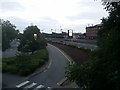
10
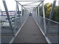
Footbridge across the North Circular Road, Neasden
Image: © David Howard
Taken: 25 Jun 2017
0.05 miles