IMAGES TAKEN NEAR TO
Quainton Street, LONDON, NW10 0BE
Introduction
This page details the photographs taken nearby to Quainton Street, NW10 0BE by members of the Geograph project.
The Geograph project started in 2005 with the aim of publishing, organising and preserving representative images for every square kilometre of Great Britain, Ireland and the Isle of Man.

There are currently over 7.5m images from over14,400 individuals and you can help contribute to the project by visiting https://www.geograph.org.uk
Image Map
Images are licensed for reuse under creativecommons.org/licenses/by-sa/2.0
Notes
- Clicking on the map will re-center to the selected point.
- The higher the marker number, the further away the image location is from the centre of the postcode.
Image Listing (57 Images Found)
Images are licensed for reuse under creativecommons.org/licenses/by-sa/2.0
Image
Details
Distance
1
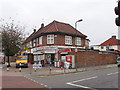
Shop on Neasden Lane
This is a local shop at the junction of Braemar Avenue and Neasden Lane.
Image: © David Hawgood
Taken: 5 Oct 2005
0.06 miles
3
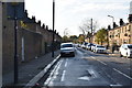
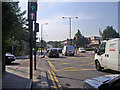
Neasden Lane
Just after crossing the River Brent from Blackbird Hill, Kingsbury
Image: © David Howard
Taken: 20 May 2017
0.08 miles
4
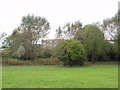
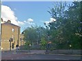
Quainton Street Open Space, Neasden
The flats beyond the park are in Poplar Grove
Image: © David Hawgood
Taken: 5 Oct 2005
0.08 miles
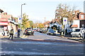
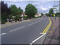
7
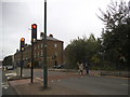
Neasden Lane North at junction of Quainton Street
Image: © David Howard
Taken: 24 Jul 2008
0.09 miles
8
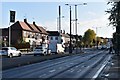
Neasden Lane approaching the underpass
Image: © David Howard
Taken: 28 Jul 2010
0.09 miles