IMAGES TAKEN NEAR TO
Chapel Close, NORWICH, NR9 4BX

Introduction

This page details the photographs taken nearby to Chapel Close, NR9 4BX by members of the Geograph project.

The Geograph project started in 2005 with the aim of publishing, organising and preserving representative images for every square kilometre of Great Britain, Ireland and the Isle of Man.

There are currently over 7.5m images from over14,400 individuals and you can help contribute to the project by visiting https://www.geograph.org.uk

Image Map


Images are licensed for reuse under creativecommons.org/licenses/by-sa/2.0
Notes
  • Clicking on the map will re-center to the selected point.
  • The higher the marker number, the further away the image location is from the centre of the postcode.

Image Listing (23 Images Found)

Images are licensed for reuse under creativecommons.org/licenses/by-sa/2.0
  • ...
Image
Details
Distance
1
Chapel Close
Image: © N Chadwick Taken: 19 Oct 2014
0.02 miles
2
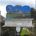
Barnham Broom Village Sign
Barnham Broom is a village situated about 4 miles north-west of Wymondham. The village sign is located on Norwich Road at the junction with Chapel Close.
Image: © G Laird Taken: 25 Oct 2017
0.02 miles
3
Barnham Broom village sign
The 'Broom' part was added in 1838, before that it was just plain old Barnham or Bernham. Ryske was another village/hamlet which was deserted in the early 1500s when Sir Edward Chamberlayne created a private estate and started building Ryskes Hall, it was completed in about 1550. The sign features a windmill which stood just east of the watermill, the building central in the picture which took its power from the River Yare. A ploughman and his horse are shown on the near-side of the river representative of the long agricultural heritage of the parish. The sign was erected in 1977, for the Queen’s silver jubilee. https://www.geograph.org.uk/photo/6803780
Image: © Adrian S Pye Taken: 8 Apr 2021
0.02 miles
4
Barnham Broom village sign
The 'Broom' part was added in 1838, before that it was just plain old Barnham or Bernham. Ryske was another village/hamlet which was deserted in the early 1500s when Sir Edward Chamberlayne created a private estate and started building Ryskes Hall, it was completed in about 1550. The sign features a windmill which stood just east of the watermill, the building central in the picture which took its power from the River Yare. A ploughman and his horse are shown on the near-side of the river representative of the long agricultural heritage of the parish. The sign was erected in 1977, for the Queen’s silver jubilee. https://www.geograph.org.uk/photo/6803777
Image: © Adrian S Pye Taken: 8 Apr 2021
0.02 miles
5
Barnham Broom Primary School
Image: © N Chadwick Taken: 19 Oct 2014
0.04 miles
6
Barnham Broom Village Sign
Image: © N Chadwick Taken: 19 Oct 2014
0.05 miles
7
Barnham Broom Primary School
Image: © N Chadwick Taken: 19 Oct 2014
0.05 miles
8
Norwich Rd
Image: © N Chadwick Taken: 19 Oct 2014
0.07 miles
9
Norwich Rd
Image: © N Chadwick Taken: 19 Oct 2014
0.08 miles
10
Rectory Farmhouse
Grade II listed. http://www.britishlistedbuildings.co.uk/en-226486-rectory-farmhouse-barnham-broom-norfolk
Image: © N Chadwick Taken: 19 Oct 2014
0.09 miles
  • ...