IMAGES TAKEN NEAR TO
Sylvan Way, NORWICH, NR8 6XD
Introduction
This page details the photographs taken nearby to Sylvan Way, NR8 6XD by members of the Geograph project.
The Geograph project started in 2005 with the aim of publishing, organising and preserving representative images for every square kilometre of Great Britain, Ireland and the Isle of Man.

There are currently over 7.5m images from over14,400 individuals and you can help contribute to the project by visiting https://www.geograph.org.uk
Image Map
Images are licensed for reuse under creativecommons.org/licenses/by-sa/2.0
Notes
- Clicking on the map will re-center to the selected point.
- The higher the marker number, the further away the image location is from the centre of the postcode.
Image Listing (12 Images Found)
Images are licensed for reuse under creativecommons.org/licenses/by-sa/2.0
Image
Details
Distance
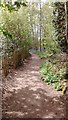
1
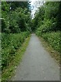
Marriott's Way in woodland east of Taverham
Image: © David Smith
Taken: 8 Jun 2024
0.16 miles
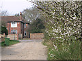
2
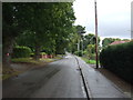
Taverham Road towards Drayton
Looking north east.
Image: © JThomas
Taken: 16 Sep 2017
0.17 miles
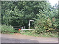
3
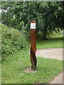
Artwork or Milepost?
I can find no information about this object beside Cycle Route 1. The plaque says Drayton 600 yds and indicates facilities for eating, drinking, sleeping and praying.
Image: © Keith Edkins
Taken: 8 Jul 2009
0.19 miles
5
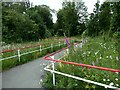
Bright railings by Marriott's Way, near Drayton
This slope links Taverham Road to the cycle route. Formerly the road crossed the railway on a bridge, but subsequent development of the station site meant the link from road to cycle route had to be made into a slope and the railings remove the temptation to speed down!
Image: © David Smith
Taken: 8 Jun 2024
0.20 miles
6
Flowering shrubs in Station Road
The Themelthorpe to Norwich Railway was built in 1882; the railway trackbed now forms part of the Marriott's Way long distance path and cycleway and the station, which used to stand at this end of the road to the right of the flowering bushes seen in the foreground, has long since closed.
Image: © Evelyn Simak
Taken: 14 Mar 2014
0.20 miles
8
Taverham - Ghost Hill Wood
Bluebell time
Image: © Jeremy Osborne
Taken: 6 May 2016
0.21 miles
9

Conifer, Drayton
A fine specimen, a cedar perhaps?
Image: © Stephen Richards
Taken: 17 Jun 2013
0.21 miles
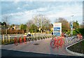
10
National Cycle Route 1, Drayton
On a disused railway. Crosses Taverham Road here.
Image: © JThomas
Taken: 16 Sep 2017
0.22 miles