IMAGES TAKEN NEAR TO
Bowthorpe Hall Road, NORWICH, NR5 9AA
Introduction
This page details the photographs taken nearby to Bowthorpe Hall Road, NR5 9AA by members of the Geograph project.
The Geograph project started in 2005 with the aim of publishing, organising and preserving representative images for every square kilometre of Great Britain, Ireland and the Isle of Man.

There are currently over 7.5m images from over14,400 individuals and you can help contribute to the project by visiting https://www.geograph.org.uk
Image Map
Images are licensed for reuse under creativecommons.org/licenses/by-sa/2.0
Notes
- Clicking on the map will re-center to the selected point.
- The higher the marker number, the further away the image location is from the centre of the postcode.
Image Listing (73 Images Found)
Images are licensed for reuse under creativecommons.org/licenses/by-sa/2.0
Image
Details
Distance
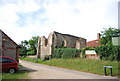
3
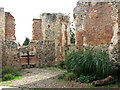
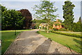
The ruined St Michael's church in Bowthorpe - view east
After extensive refurbishment in the 1630s, St Michael's church had dilapidated only a century later. Its chancel roof was removed in 1792. The round church tower was in use as a chimney for a brick-lined oven or a corn dryer and the structure was used for housing pigs. All that remains today are the chancel walls which are adjoined by the Church Centre > http://www.geograph.org.uk/photo/2062687 in the west and the garden of remembrance in the south. In the 1980s a skeleton was discovered sealed within the old oven.
Image: © Evelyn Simak
Taken: 12 Sep 2010
0.02 miles
7
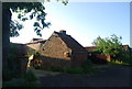
The ruins of St Michael's Church, Bowthorpe
The church dates back to the 14th century but has been abandoned and ruined for hundreds of years.
Image: © N Chadwick
Taken: 1 Jul 2010
0.03 miles
8
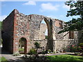
Bowthorpe St. Michael's ruined church and Memorial
Bowthorpe War Memorial is represented at this ruin.
The names of the two men recorded lost in WW1 are :A.E. HOLMES who served as a Gunner in the Canadian Artillery Pool. He died age 25, 10/10/1918; and
Donald Edward LONG a Private who served in the 2nd Btt'n Norfolk Regt. He was killed at the age of 21 on 29/03/1916.
The WW2 losses in the parish were all civilian and are recorded in City Hall.
Image: © Adrian S Pye
Taken: 14 Jun 2009
0.03 miles