IMAGES TAKEN NEAR TO
Mangreen Lane, NORWICH, NR4 6US
Introduction
This page details the photographs taken nearby to Mangreen Lane, NR4 6US by members of the Geograph project.
The Geograph project started in 2005 with the aim of publishing, organising and preserving representative images for every square kilometre of Great Britain, Ireland and the Isle of Man.

There are currently over 7.5m images from over14,400 individuals and you can help contribute to the project by visiting https://www.geograph.org.uk
Image Map
Images are licensed for reuse under creativecommons.org/licenses/by-sa/2.0
Notes
- Clicking on the map will re-center to the selected point.
- The higher the marker number, the further away the image location is from the centre of the postcode.
Image Listing (49 Images Found)
Images are licensed for reuse under creativecommons.org/licenses/by-sa/2.0
Image
Details
Distance
1
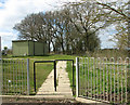
Paved path at Brooks Green
Brooks Green (formerly known as Harford) was opened in 2009. The site, which is leased from a private land owner, accommodates 8 Traveller families and is managed by the Broadland Housing Association. Situated near to the Harford Park & Ride car park, at the southern end of the northern section of a rural lane called Mangreen, it comprises eight pitches, each consisting of a living area and a hard standing suitable for up to three or four caravans with separate car parking spaces for each unit. There is also a secure site compound (depicted here) which can be used for communal or other activities.
Image: © Evelyn Simak
Taken: 6 Apr 2015
0.02 miles
2
Brooks Green
Brooks Green (formerly known as Harford) was opened in 2009. The site, which is leased from a private land owner, accommodates 8 Traveller families and is managed by the Broadland Housing Association. Situated near to the Harford Park & Ride car park, at the southern end of the northern section of a rural lane called Mangreen, it comprises eight pitches, each consisting of a living area and a hard standing suitable for up to three or four caravans with separate car parking spaces for each unit. There is also a secure site compound which can be used for communal or other activities.
Image: © Evelyn Simak
Taken: 6 Apr 2015
0.02 miles
3
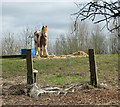
A skewbald pony at Brooks Green
Brooks Green (formerly known as Harford) was opened in 2009. The site > http://www.geograph.org.uk/photo/4416417 which is leased from a private land owner, accommodates 8 Traveller families and is managed by the Broadland Housing Association. Situated near to the Harford Park & Ride car park, at the southern end of the northern section of a rural lane called Mangreen, it comprises eight pitches, each consisting of a living area and a hard standing suitable for up to three or four caravans with separate car parking spaces for each unit. There is also a secure site compound > http://www.geograph.org.uk/photo/4416422 which can be used for communal or other activities.
Image: © Evelyn Simak
Taken: 6 Apr 2015
0.04 miles
4
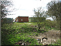
Pasture at Brooks Green
Brooks Green (formerly known as Harford) was opened in 2009. The site > http://www.geograph.org.uk/photo/4416417 which is leased from a private land owner, accommodates 8 Traveller families and is managed by the Broadland Housing Association. Situated near to the Harford Park & Ride car park, at the southern end of the northern section of a rural lane called Mangreen, it comprises eight pitches, each consisting of a living area and a hard standing suitable for up to three or four caravans with separate car parking spaces for each unit. There is also a secure site compound > http://www.geograph.org.uk/photo/4416422 which can be used for communal or other activities.
Image: © Evelyn Simak
Taken: 6 Apr 2015
0.04 miles
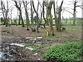
5
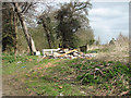
Fly-tipping at Brooks Green
Brooks Green (formerly known as Harford) was opened in 2009. The site > http://www.geograph.org.uk/photo/4416417 which is leased from a private land owner, accommodates 8 Traveller families and is managed by the Broadland Housing Association. Situated near to the Harford Park & Ride car park, at the southern end of the northern section of a rural lane called Mangreen, it comprises eight pitches, each consisting of a living area and a hard standing suitable for up to three or four caravans with separate car parking spaces for each unit. There is also a secure site compound > http://www.geograph.org.uk/photo/4416422 which can be used for communal or other activities.
Image: © Evelyn Simak
Taken: 6 Apr 2015
0.04 miles
6
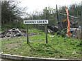
Brooks Green sign
Brooks Green (formerly known as Harford) was opened in 2009. The site > http://www.geograph.org.uk/photo/4416417 which is leased from a private land owner, accommodates 8 Traveller families and is managed by the Broadland Housing Association. Situated near to the Harford Park & Ride car park, at the southern end of the northern section of a rural lane called Mangreen, it comprises eight pitches, each consisting of a living area and a hard standing suitable for up to three or four caravans with separate car parking spaces for each unit. There is also a secure site compound > http://www.geograph.org.uk/photo/4416422 which can be used for communal or other activities.
Image: © Evelyn Simak
Taken: 6 Apr 2015
0.05 miles
7
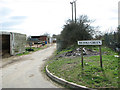
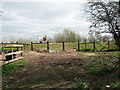
Mangreen at Brooks Green
This is the southern end of the northern section of a lane called Mangreen, which was cut into two sections by the construction of the A47 Norwich bypass road.
Brooks Green (formerly known as Harford) was opened in 2009. The site > http://www.geograph.org.uk/photo/4416417 which is leased from a private land owner, accommodates 8 Traveller families and is managed by the Broadland Housing Association. Situated near to the Harford Park & Ride car park, at the southern end of the northern section of a rural lane called Mangreen, it comprises eight pitches, each consisting of a living area and a hard standing suitable for up to three or four caravans with separate car parking spaces for each unit. There is also a secure site compound > http://www.geograph.org.uk/photo/4416422 which can be used for communal or other activities.
Image: © Evelyn Simak
Taken: 6 Apr 2015
0.07 miles
8
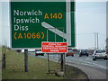
Avian Influenza (Bird Flu) Sign
Avian influenza (bird flu) sign at the junction of the A47 and the A140. This has become an entrance of the restricted zone more info see http://www.bbc.co.uk/suffolk/content/articles/2007/02/05/bird_flu_holton_reaction_feature.shtml
Image: © Keith Evans
Taken: 16 Feb 2007
0.07 miles
9
Water main marker post
The pipe would seem to be leaking, like many others here in Norfolk.
Image: © Evelyn Simak
Taken: 6 Apr 2015
0.07 miles
10
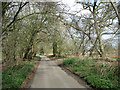
View along the northern section of Mangreen
The lane was cut into two sections by the construction of the A47 Norwich bypass road.
Image: © Evelyn Simak
Taken: 6 Apr 2015
0.08 miles