IMAGES TAKEN NEAR TO
Stobart Close, BECCLES, NR34 9LT
Introduction
This page details the photographs taken nearby to Stobart Close, NR34 9LT by members of the Geograph project.
The Geograph project started in 2005 with the aim of publishing, organising and preserving representative images for every square kilometre of Great Britain, Ireland and the Isle of Man.

There are currently over 7.5m images from over14,400 individuals and you can help contribute to the project by visiting https://www.geograph.org.uk
Image Map
Images are licensed for reuse under creativecommons.org/licenses/by-sa/2.0
Notes
- Clicking on the map will re-center to the selected point.
- The higher the marker number, the further away the image location is from the centre of the postcode.
Image Listing (47 Images Found)
Images are licensed for reuse under creativecommons.org/licenses/by-sa/2.0
Image
Details
Distance
1
Petit Couronne Way
Petit Couronne is a town in the Normandy region of northern France which is twinned with the town of Beccles in Suffolk.
Image: © Adrian S Pye
Taken: 1 Jun 2022
0.09 miles
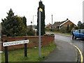
2
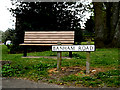
Banham Road sign & Seat
On Banham Road at the junction with Coney Hill
Image: © Geographer
Taken: 18 Apr 2014
0.10 miles
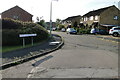
3
Banham Road, Beccles
At the junction with Coney Hill
Image: © Geographer
Taken: 18 Apr 2014
0.11 miles
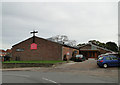
4
St.Luke's Church & Rigbourne Hill Community Centre
Off Rigbourne Hill at the junction with Castle Hill & Coney Hill
http://www.becclesparish.org.uk/st%20luke%27s.html
Image: © Geographer
Taken: 13 Feb 2014
0.14 miles
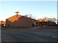
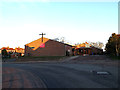
6
Beccles St Luke's church, Rigbourne Hill
St Luke's church was built in the 1960s as a result of the increased population in this, the southern part of the town.
Image: © Adrian S Pye
Taken: 13 Nov 2010
0.14 miles
7
St.Luke's Church & Rigbourne Hill Community Centre
Off Rigbourne Hill at the junction with Castle Hill & Coney Hill
http://www.becclesparish.org.uk/st%20luke%27s.html
Image: © Geographer
Taken: 13 Feb 2014
0.14 miles
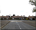
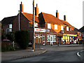
8
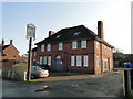
Formerly 'The Castle' public house
'The Castle' was built after the Second World War for the benefit of the residents of Rigbourne Hill and the other surrounding post war housing estates.
It would appear to have recently been divided into flats.
Image: © Adrian S Pye
Taken: 14 Feb 2017
0.14 miles
10

St.Luke's Church & Rigbourne Hill Community Centre sign
Off Rigbourne Hill at the junction with Castle Hill & Coney Hill
http://www.becclesparish.org.uk/st%20luke%27s.html
Image: © Geographer
Taken: 13 Feb 2014
0.15 miles