IMAGES TAKEN NEAR TO
Dyers Yard, NORWICH, NR3 3QY
Introduction
This page details the photographs taken nearby to Dyers Yard, NR3 3QY by members of the Geograph project.
The Geograph project started in 2005 with the aim of publishing, organising and preserving representative images for every square kilometre of Great Britain, Ireland and the Isle of Man.

There are currently over 7.5m images from over14,400 individuals and you can help contribute to the project by visiting https://www.geograph.org.uk
Image Map
Images are licensed for reuse under creativecommons.org/licenses/by-sa/2.0
Notes
- Clicking on the map will re-center to the selected point.
- The higher the marker number, the further away the image location is from the centre of the postcode.
Image Listing (2772 Images Found)
Images are licensed for reuse under creativecommons.org/licenses/by-sa/2.0
Image
Details
Distance
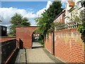
1
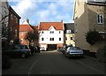
New housing in Dyers Yard
Off Coslany Street. Before redevelopment, this used to be Chequers Yard.
Image: © Evelyn Simak
Taken: 1 Feb 2020
0.01 miles
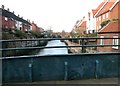
3
![The view from St Miles Bridge [2]](https://s3.geograph.org.uk/geophotos/05/12/53/5125391_9d3b079a_120x120.jpg)
The view from St Miles Bridge [2]
Looking north west, upstream.
Image: © Michael Dibb
Taken: 4 Sep 2016
0.02 miles
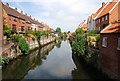
4
View along the River Wensum from St Miles Bridge
This view also shows the (currently closed) opening of the spout > https://www.geograph.org.uk/photo/6382307 which allows water to run off the bridge quickly when open.
Image: © Evelyn Simak
Taken: 1 Feb 2020
0.02 miles
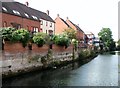
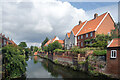
5
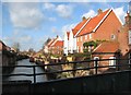
Houses in Dyers Yard
By the River Wensum, as seen from St Miles Bridge.
Image: © Evelyn Simak
Taken: 1 Feb 2020
0.03 miles
6
Brick arch on the Riverside Walk along the Wensum
Image: © Evelyn Simak
Taken: 15 Sep 2018
0.03 miles
7
New housing in Indigo Yard
Off Oak Street. Before redevelopment, this used to be Tuns Yard.
Image: © Evelyn Simak
Taken: 1 Feb 2020
0.03 miles
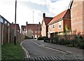
9
New housing in Dyers Yard
Off Coslany Street. Before redevelopment, this used to be Chequers Yard.
Image: © Evelyn Simak
Taken: 1 Feb 2020
0.03 miles
10
River Wensum
Just below the limit of navigation for boats, which is up by the trees in the distance.
Image: © Des Blenkinsopp
Taken: 31 Jul 2021
0.03 miles