IMAGES TAKEN NEAR TO
Catton Grove Road, NORWICH, NR3 3PB
Introduction
This page details the photographs taken nearby to Catton Grove Road, NR3 3PB by members of the Geograph project.
The Geograph project started in 2005 with the aim of publishing, organising and preserving representative images for every square kilometre of Great Britain, Ireland and the Isle of Man.

There are currently over 7.5m images from over14,400 individuals and you can help contribute to the project by visiting https://www.geograph.org.uk
Image Map
Images are licensed for reuse under creativecommons.org/licenses/by-sa/2.0
Notes
- Clicking on the map will re-center to the selected point.
- The higher the marker number, the further away the image location is from the centre of the postcode.
Image Listing (3 Images Found)
Images are licensed for reuse under creativecommons.org/licenses/by-sa/2.0
Image
Details
Distance
1
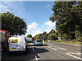
A1042 Mile Cross Lane, Catton
At the junction with St.Faith's and Catton Grove Roads
Image: © Geographer
Taken: 15 Oct 2014
0.03 miles
2
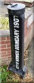
Old Boundary Marker by Oak Lane, Norwich
Municipal Boundary Marker by the UC road, in parish of Norwich (Norwich District), No. 26 Oak Lane, New Sprowston, on verge.
Inscription reads vertically:-
CITY OF NORWICH BOUNDARY 1907
{arrow on top}
Surveyed
Milestone Society National ID: NO_NORW01pb
Image: © Milestone Society
Taken: Unknown
0.08 miles
3
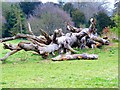
Fallen Tree
A fallen Tree, located in the centre of Catton Park
Image: © karl ward
Taken: 8 Apr 2012
0.19 miles