IMAGES TAKEN NEAR TO
Harrington Avenue, LOWESTOFT, NR32 4JU
Introduction
This page details the photographs taken nearby to Harrington Avenue, NR32 4JU by members of the Geograph project.
The Geograph project started in 2005 with the aim of publishing, organising and preserving representative images for every square kilometre of Great Britain, Ireland and the Isle of Man.

There are currently over 7.5m images from over14,400 individuals and you can help contribute to the project by visiting https://www.geograph.org.uk
Image Map
Images are licensed for reuse under creativecommons.org/licenses/by-sa/2.0
Notes
- Clicking on the map will re-center to the selected point.
- The higher the marker number, the further away the image location is from the centre of the postcode.
Image Listing (31 Images Found)
Images are licensed for reuse under creativecommons.org/licenses/by-sa/2.0
Image
Details
Distance
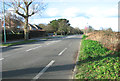
1
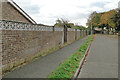
Harrington Avenue, Gunton
The former railway line ran just the other side of this wall.
Image: © Adrian S Pye
Taken: 15 Oct 2022
0.05 miles
2
Former railway crossing and footbridge at Hubbards Loke
Image: © Adrian S Pye
Taken: 15 Oct 2022
0.15 miles
3
Footpath across a former railway crossing and footbridge
Two of the original crossing gate posts are still extant.
Image: © Adrian S Pye
Taken: 15 Oct 2022
0.15 miles
4
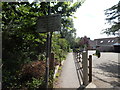
Public Footpath to St. Peter Church Gunton, Suffolk
Image: © Suse
Taken: 26 May 2007
0.15 miles
5
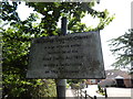
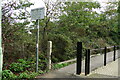
No riding motor cyclists on this byway
The sign reads" Waveney District Council
It is an offence under
Section 36 of the
Road Traffic Act 1972
to ride a motorcycle on this bridleway". See http://www.legislation.gov.uk/ukpga/1972/20/enacted for the source document and Image for an overview of the path.
Image: © Hamish Griffin
Taken: 31 Jul 2014
0.16 miles
6
Path to Corton Road
Off Hubbards Loke.
Image: © Hamish Griffin
Taken: 31 Jul 2014
0.16 miles
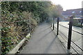
9
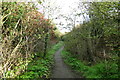
Path along the former railway track
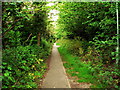
The hedges are encroaching onto the pathway which is well-used by dog walkers and locals out for some fresh air. The path is just under 800 yards until reaching the Pleasurewood Hills amusement park bridge and another east/west footpath crossing this one.
Image: © Adrian S Pye
Taken: 15 Oct 2022
0.19 miles