IMAGES TAKEN NEAR TO
Normanshurst Close, LOWESTOFT, NR32 2RF
Introduction
This page details the photographs taken nearby to Normanshurst Close, NR32 2RF by members of the Geograph project.
The Geograph project started in 2005 with the aim of publishing, organising and preserving representative images for every square kilometre of Great Britain, Ireland and the Isle of Man.

There are currently over 7.5m images from over14,400 individuals and you can help contribute to the project by visiting https://www.geograph.org.uk
Image Map
Images are licensed for reuse under creativecommons.org/licenses/by-sa/2.0
Notes
- Clicking on the map will re-center to the selected point.
- The higher the marker number, the further away the image location is from the centre of the postcode.
Image Listing (25 Images Found)
Images are licensed for reuse under creativecommons.org/licenses/by-sa/2.0
Image
Details
Distance
1
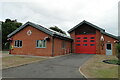
Lowestoft North Fire Station
Located in Normanston Drive on the north side of the bridge it is essential for incidents when the bridge is closed for marine traffic or repairs as the main fire station is on the south side of the water.
Image
Image: © Adrian S Pye
Taken: 24 Jul 2022
0.07 miles
2

Normanshurst (Lowestoft) new fire station
Normanshurst (Lowestoft) new fire station, Normanshurst Drive, Lowestoft, Suffolk, being built to replace Image
Image: © Kevin Hale
Taken: 29 Jun 2010
0.08 miles
3
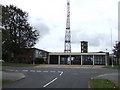
Lowestoft Fire Station
Lowestoft Fire Station, Normanston Drive, Lowestoft, Suffolk.
Image: © Keith Evans
Taken: 1 Oct 2007
0.09 miles
4
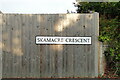
Skamacre Crescent street sign, Lowestoft
Skamacre Heath was a large area of ancient heathland approximately where this road is today. Skamacre is a word I can find used nowhere else in the English language.
Image: © Adrian S Pye
Taken: 21 Aug 2022
0.11 miles
6
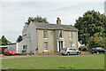
The Beeches, Lowestoft
The former early 19th century country house is grade II listed
Image: © Adrian S Pye
Taken: 22 Sep 2022
0.17 miles
7
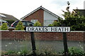
Drakes Heath street sign, Lowestoft
Drakes Heath is an ancient name for the Heathland which once covered the land north to Normanston from Lake Lothing as shown on the 1618 map of Lowestoft.
Image: © Adrian S Pye
Taken: 21 Aug 2022
0.20 miles
8
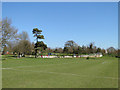
Skateboarding area on Normanston Park, Oulton Broad
Image: © Adrian S Pye
Taken: 19 Mar 2011
0.20 miles
9
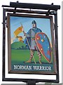
The Norman Warrior sign
The Norman Warrior Pub sign Fir Lane, Lowestoft, Suffolk.
Image: © Keith Evans
Taken: 1 Oct 2007
0.20 miles
10
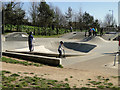
Skate boarding area in Normanston Park, Oulton Broad
There were more scooters than skateboards.
Image: © Adrian S Pye
Taken: 19 Mar 2011
0.20 miles