IMAGES TAKEN NEAR TO
Kimberley Terrace, GREAT YARMOUTH, NR30 3JD
Introduction
This page details the photographs taken nearby to Kimberley Terrace, NR30 3JD by members of the Geograph project.
The Geograph project started in 2005 with the aim of publishing, organising and preserving representative images for every square kilometre of Great Britain, Ireland and the Isle of Man.

There are currently over 7.5m images from over14,400 individuals and you can help contribute to the project by visiting https://www.geograph.org.uk
Image Map
Images are licensed for reuse under creativecommons.org/licenses/by-sa/2.0
Notes
- Clicking on the map will re-center to the selected point.
- The higher the marker number, the further away the image location is from the centre of the postcode.
Image Listing (452 Images Found)
Images are licensed for reuse under creativecommons.org/licenses/by-sa/2.0
Image
Details
Distance
1
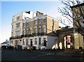
Kimberley Terrace as seen from Camperdown
Image: © Evelyn Simak
Taken: 13 Nov 2018
0.01 miles
2
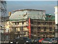
Revamping Great Yarmouth.
These are some of the Victorian buildings be modernised along the sea front.
Image: © Bob Crook
Taken: 8 Jan 2008
0.01 miles
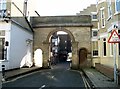
3
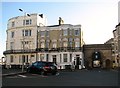
Kimberley Terrace as seen from Wellington Road
The archway at right is the Wellington Mews Arch, providing access to the mews behind Kinberley Terrace. It dates from 1847 and is Grade 2 listed.
Image: © Evelyn Simak
Taken: 13 Nov 2018
0.01 miles
4
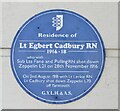
Great Yarmouth - Lt Egbert Cadbury RN
Blue plaque to a hero of WW1 who shot down Zeppelins.
www.great-yarmouth.co.uk
Image: © Colin Smith
Taken: 17 Aug 2020
0.01 miles
5
Another Wellington Arch?
The second of the two arches on Wellington Road. Not as grand as the first which stands less than 100m away and is not listed, but still slightly incongruous in its current surroundings
Image: © Helen Steed
Taken: 5 May 2012
0.01 miles
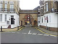
6
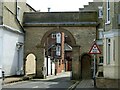
The Wellington Mews Arch
The Grade 2 listed archway depicted here is known as the Wellington Mews Arch. It dates from 1847 and forms the entrance to the mews behind Kimberley Terrace. It is complemented by a larger arch known as Wellington Arch, situated at the southern end of Wellington Road.
Image: © Evelyn Simak
Taken: 13 Nov 2018
0.01 miles
7
The Wellington Mews Arch
The Grade 2 listed archway depicted here is known as the Wellington Mews Arch. It dates from 1847 and forms the entrance to the mews behind Kimberley Terrace. It is complemented by a larger arch known as Wellington Arch, situated at the southern end of Wellington Road.
Image: © Evelyn Simak
Taken: 13 Nov 2018
0.01 miles
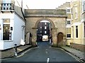
8
The Wellington Arches
The Grade 2 listed archway depicted here is known as the Wellington Mews Arch. It dates from 1847 and forms the entrance to the mews behind Kimberley Terrace and is complemented by a larger arch known as Wellington Arch, situated at the southern end of Wellington Road on the north side of Camperdown.
Image: © Evelyn Simak
Taken: 13 Nov 2018
0.01 miles
9
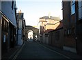
View north on Wellington Mews
The narrow road links Camperdown and Albert Square. The Grade 2 listed archway at the northern end of the mews is known as the Wellington Mews Arch. It dates from 1847 and forms the entrance to the mews behind Kimberley Terrace and is complemented by a larger arch known as Wellington Arch, situated at the southern end of Wellington Road on the north side of Camperdown.
Image: © Evelyn Simak
Taken: 13 Nov 2018
0.01 miles
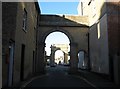
10
Wellington Mews Arch, Great Yarmouth
Forming a complement to the larger Wellington arch https://www.geograph.org.uk/photo/7841439 on the north side of Camperdown. Built 1847, Listed Grade II.
Image: © Alan Murray-Rust
Taken: 27 Jul 2024
0.01 miles