IMAGES TAKEN NEAR TO
Acle New Road, NR30 1AU
Introduction
This page details the photographs taken nearby to Acle New Road, NR30 1AU by members of the Geograph project.
The Geograph project started in 2005 with the aim of publishing, organising and preserving representative images for every square kilometre of Great Britain, Ireland and the Isle of Man.

There are currently over 7.5m images from over14,400 individuals and you can help contribute to the project by visiting https://www.geograph.org.uk
Image Map
Images are licensed for reuse under creativecommons.org/licenses/by-sa/2.0
Notes
- Clicking on the map will re-center to the selected point.
- The higher the marker number, the further away the image location is from the centre of the postcode.
Image Listing (136 Images Found)
Images are licensed for reuse under creativecommons.org/licenses/by-sa/2.0
Image
Details
Distance
1
North Quay (A149), Great Yarmouth
Looking south.
Image: © JThomas
Taken: 27 Apr 2016
0.07 miles
2
Superfluous apostrophe at Runham Vauxhall
MOT'S?
Image: © Adrian S Pye
Taken: 30 Jan 2015
0.08 miles
3
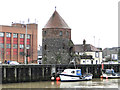
Northwest Tower from Runham Vauxhall
With a height of 9.2m the tower is one of 16 originally built. Dating from around 1344 it once formed part of the town's Medieval walls. The wall complex is one of the earliest examples of brick usage in East Anglia that can be dated with any accuracy. The walls, originally sanctioned by King Henry III, were built between 1285 and circa 1400. The tower was restored in the 1960s and again in 1987.
Image: © Adrian S Pye
Taken: 30 Jan 2015
0.08 miles
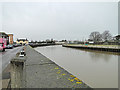
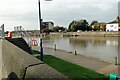
7
The site of the former railway bridge over the River Bure
The bridge crossed at an angle and would have terminated at the spot where the lifebelt can be seen on the opposite bank.
The bridge was elevated about 12 feet above the river bank allowing river traffic to pass beneath.
Image: © Adrian S Pye
Taken: 29 Oct 2022
0.10 miles
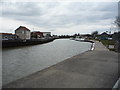
8
From the eastern Bank of the River Bure
On the line of the former bridge the pilings on the opposite bank are the near the point where the bridge terminated.
The bridge was elevated about 12 feet above the river bank allowing river traffic to pass beneath.
Image: © Adrian S Pye
Taken: 29 Oct 2022
0.10 miles
9
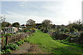
Former line of the railway track
The line passed through the allotments along the line of this path and crossing the area where Lawn Road has since been built.
Image: © Adrian S Pye
Taken: 29 Oct 2022
0.10 miles