IMAGES TAKEN NEAR TO
Moregrove Lane, GREAT YARMOUTH, NR29 4QA
Introduction
This page details the photographs taken nearby to Moregrove Lane, NR29 4QA by members of the Geograph project.
The Geograph project started in 2005 with the aim of publishing, organising and preserving representative images for every square kilometre of Great Britain, Ireland and the Isle of Man.

There are currently over 7.5m images from over14,400 individuals and you can help contribute to the project by visiting https://www.geograph.org.uk
Image Map
Images are licensed for reuse under creativecommons.org/licenses/by-sa/2.0
Notes
- Clicking on the map will re-center to the selected point.
- The higher the marker number, the further away the image location is from the centre of the postcode.
Image Listing (40 Images Found)
Images are licensed for reuse under creativecommons.org/licenses/by-sa/2.0
Image
Details
Distance
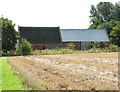
3
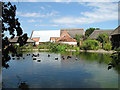
Moregrove Manor Barn
The manor no longer exists. The two barns date from the 19th century and are Grade II listed.
Image: © Evelyn Simak
Taken: 16 Aug 2015
0.08 miles
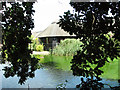
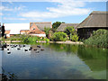
4
Pond by Moregrove Manor Barn
The manor no longer exists. The two barns date from the 19th century and are Grade II listed.
Image: © Evelyn Simak
Taken: 16 Aug 2015
0.08 miles
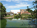
5
Moregrove Manor barn and barn conversions
The manor no longer exists. The two barns date from the 19th century and are Grade II listed.
Image: © Evelyn Simak
Taken: 16 Aug 2015
0.08 miles
6
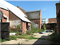
Barns by Moregrove Farm
The farm no longer exists. The two barns date from the 19th century and are Grade II listed.
Image: © Evelyn Simak
Taken: 16 Aug 2015
0.08 miles
7
Barns by Moregrove Farm
The farm no longer exists; the two barns date from the 19th century and are Grade II listed.
Image: © Evelyn Simak
Taken: 16 Aug 2015
0.09 miles
8
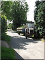
The end of Damgate Lane
Damgate Lane turns off Staithe Road, leading in northerly direction; it peters out into a track > http://www.geograph.org.uk/photo/929580 by Moregrove Farm.
Image: © Evelyn Simak
Taken: 20 Aug 2008
0.09 miles