IMAGES TAKEN NEAR TO
Hall Street, MELTON CONSTABLE, NR24 2LG
Introduction
This page details the photographs taken nearby to Hall Street, NR24 2LG by members of the Geograph project.
The Geograph project started in 2005 with the aim of publishing, organising and preserving representative images for every square kilometre of Great Britain, Ireland and the Isle of Man.

There are currently over 7.5m images from over14,400 individuals and you can help contribute to the project by visiting https://www.geograph.org.uk
Image Map
Images are licensed for reuse under creativecommons.org/licenses/by-sa/2.0
Notes
- Clicking on the map will re-center to the selected point.
- The higher the marker number, the further away the image location is from the centre of the postcode.
Image Listing (26 Images Found)
Images are licensed for reuse under creativecommons.org/licenses/by-sa/2.0
Image
Details
Distance
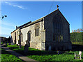
1
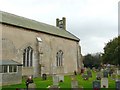
All Saints Church, Briston, showing the bell turret
There had been a round tower, but it collapsed in 1795 and replaced by a square cupola, which in turn has been replaced by the present utilitarian structure. The bell was made in 1638 by Brend. The north aisle was demolished in 1785, and the outline of the arcade can still be seen.
Image: © Humphrey Bolton
Taken: 1 Nov 2008
0.10 miles
2
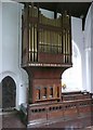
The organ, All Saints Church, Briston
Church organs are often in a loft, and can be overlooked by visitors. This one was made by Bishop & Sons in the 19C. This is the church that has a metal cello, made and played by the village blacksmith about 1700.
Image: © Humphrey Bolton
Taken: 1 Nov 2008
0.10 miles
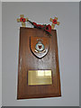
3
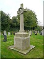
War memorial, All Saints Church, Briston
This one has a laurel wreath over a sword that is within a cross. The lettering is raised on a recessed ground.
Image: © Humphrey Bolton
Taken: 1 Nov 2008
0.10 miles
6
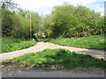
Rural crossroads
None of these country lanes has a name - the road seen straight ahead links with Hall Street further to the east. The bridge seen in mid-distance takes the road over the River Bure which here is nothing more than a small stream > http://www.geograph.org.uk/photo/1278078. The stream here crosses the lane via a culvert which runs underneath it, only to cross underneath another lane at the same junction about 20 metres further to the west > http://www.geograph.org.uk/photo/1278144.
The River Bure rises near Melton Constable, 18 kilometres miles upstream of Aylsham, which was the original head of navigation. It flows into the North Sea by Breydon Water near Gorleston, further to the southeast.
Image: © Evelyn Simak
Taken: 29 Apr 2009
0.12 miles
7
WW2 aircraft crash memorial at Briston
The memorial is in Briston church and bears three names of the crew of a Wellington which crashed in the village.
The names are: Colin George Charles FROST, Edward Horatio NANCARROW and Bernard Montague Jeffrey VINCENT. There is also a plaque near the site of the crash, of which I, as yet have no image.
Image: © Adrian S Pye
Taken: 22 Jul 2015
0.13 miles
8
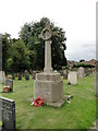
Briston War Memorial
The Memorial which stands in the churchyard bears 25 names of the men lost in WW1. There are also seven names of men lost in WW2. There is also a headstone in the churchyard for George James DAPLYN (Royal Army Ordnance Corps) who died in WW2 but is not named on the memorial.
Image: © Adrian S Pye
Taken: 22 Jul 2015
0.13 miles
10
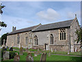
Briston All Saints' church
The tower fell down and was completely demolished in 1724 and a single bell turret was erected at a later date, rather than having the enormous expense of rebuilding the tower. The north aisle was also demolished but it is not certain whether the two events are connected.
Image: © Adrian S Pye
Taken: 16 Aug 2009
0.13 miles