IMAGES TAKEN NEAR TO
Fakenham Road, MELTON CONSTABLE, NR24 2HJ
Introduction
This page details the photographs taken nearby to Fakenham Road, NR24 2HJ by members of the Geograph project.
The Geograph project started in 2005 with the aim of publishing, organising and preserving representative images for every square kilometre of Great Britain, Ireland and the Isle of Man.

There are currently over 7.5m images from over14,400 individuals and you can help contribute to the project by visiting https://www.geograph.org.uk
Image Map
Images are licensed for reuse under creativecommons.org/licenses/by-sa/2.0
Notes
- Clicking on the map will re-center to the selected point.
- The higher the marker number, the further away the image location is from the centre of the postcode.
Image Listing (15 Images Found)
Images are licensed for reuse under creativecommons.org/licenses/by-sa/2.0
Image
Details
Distance
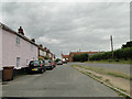
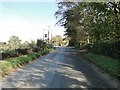
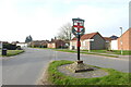
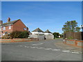
2
Fakenham Road (B1354)
Near Manor Farm.
Image: © J.Hannan-Briggs
Taken: 16 Feb 2014
0.14 miles
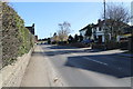
3
The Crossways, Briston
Where Holt Road and the primary route, Norwich Road cross
Image: © Adrian S Pye
Taken: 23 Oct 2018
0.15 miles
4
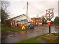
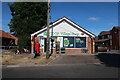
Briston: village sign and post office
The village sign stands on the small triangular green on the acute junction of Church Street (running across picture) and Holt Road (off to the right). Facing the junction is the village store and post office.
Image: © Chris Downer
Taken: 30 Nov 2009
0.16 miles
5
Post Office, Briston
See Image for an earlier view
Image: © Hugh Venables
Taken: 16 Jul 2022
0.16 miles
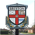
6
Village sign
See also > http://www.geograph.org.uk/photo/787325
Image: © Evelyn Simak
Taken: 3 May 2008
0.17 miles
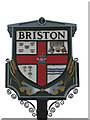
7
Briston village sign
The sign is double sided and identical on both. It is surmounted by a tiny wheatsheaf, and divided into four grounds by a red cross. Top right are five crowns for a reason I have yet to establish. The five bar gate and farm animals and the wheatsheaves below are representing the agricultural heritage of the parish, as are the ears of wheat below the shield.
The River Bure, which is represented by the wavy blue lines, bottom right. In the centre is a merry-go-round reminiscent of the fair held on the village green. https://www.geograph.org.uk/photo/6800228
Image: © Adrian S Pye
Taken: 31 Mar 2021
0.17 miles
8
Briston village sign
The sign is double sided and identical on both. It is surmounted by a tiny wheatsheaf, and divided into four grounds by a red cross. Top right are five crowns for a reason I have yet to establish. The five bar gate and farm animals and the wheatsheaves below are representing the agricultural heritage of the parish, as are the ears of wheat below the shield.
The River Bure, which is represented by the wavy blue lines, bottom right. In the centre is a merry-go-round reminiscent of the fair held on the village green. https://www.geograph.org.uk/photo/6800224
Image: © Adrian S Pye
Taken: 31 Mar 2021
0.17 miles
10
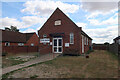
Salvation Army hall, Briston
See Image for an earlier view. The addition of the food bank banner is telling of some of the changes since 2008.
Image: © Hugh Venables
Taken: 16 Jul 2022
0.19 miles