IMAGES TAKEN NEAR TO
Main Road, WELLS-NEXT-THE-SEA, NR23 1RL
Introduction
This page details the photographs taken nearby to Main Road, NR23 1RL by members of the Geograph project.
The Geograph project started in 2005 with the aim of publishing, organising and preserving representative images for every square kilometre of Great Britain, Ireland and the Isle of Man.

There are currently over 7.5m images from over14,400 individuals and you can help contribute to the project by visiting https://www.geograph.org.uk
Image Map
Images are licensed for reuse under creativecommons.org/licenses/by-sa/2.0
Notes
- Clicking on the map will re-center to the selected point.
- The higher the marker number, the further away the image location is from the centre of the postcode.
Image Listing (41 Images Found)
Images are licensed for reuse under creativecommons.org/licenses/by-sa/2.0
Image
Details
Distance
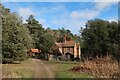
2
Meals House near Holkham Gap
Meals House shown here lies on the publicly accessible trackway that skirts the southern edge of the pinewoods to the west of Holkham Gap.
Image: © Nigel Stickells
Taken: 17 Apr 2007
0.02 miles
5
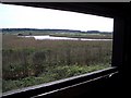
View from inside the Washington Hide at Holkham
A plaque on the exterior of the George Washington Hide indicates that it was opened by Viscount Coke on 22 July 1998. This view, looking SSW, shows part of the wonderful panorama available to keen watchers of the many water birds to be found in and around the marshes associated with the Holkham National Nature Reserve.
Image: © Nigel Stickells
Taken: 17 Apr 2007
0.11 miles
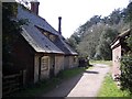
6
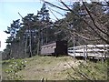
The Washington Hide at Holkham
The Washington Hide with easy disabled access is well placed on the southern edge of the pinewoods overlooking the marshes of the Holkham National Nature Reserve, see the associated views in this square.
Image: © Nigel Stickells
Taken: 17 Apr 2007
0.13 miles
7
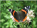
Red Admiral butterfly
on Hemp Agrimony near Image See also http://en.wikipedia.org/wiki/Red_Admiral
Image: © Zorba the Geek
Taken: 3 Aug 2008
0.13 miles
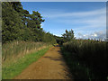
8
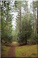
Woodland path, Holkham
Mapped as the coast path by the OS, but not, I think, waymarked as such.
Image: © Derek Harper
Taken: 1 Jan 2016
0.13 miles
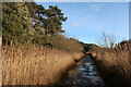
9
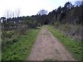
Track to Burrow Gap at Holkham
This track runs along the landward side of the pinewoods that line Holkham Bay. It runs from Lady Ann's Drive, which provides access to Holkham Gap, and the
Burrow Gap about a mile to the west.
Image: © Nigel Stickells
Taken: 17 Apr 2007
0.13 miles
10
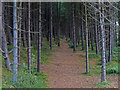
Woodland near the dunes at Holkham Bay
Image: © Mat Fascione
Taken: 14 Sep 2017
0.14 miles