IMAGES TAKEN NEAR TO
Wessex Street, NORWICH, NR2 2SY
Introduction
This page details the photographs taken nearby to Wessex Street, NR2 2SY by members of the Geograph project.
The Geograph project started in 2005 with the aim of publishing, organising and preserving representative images for every square kilometre of Great Britain, Ireland and the Isle of Man.

There are currently over 7.5m images from over14,400 individuals and you can help contribute to the project by visiting https://www.geograph.org.uk
Image Map
Images are licensed for reuse under creativecommons.org/licenses/by-sa/2.0
Notes
- Clicking on the map will re-center to the selected point.
- The higher the marker number, the further away the image location is from the centre of the postcode.
Image Listing (641 Images Found)
Images are licensed for reuse under creativecommons.org/licenses/by-sa/2.0
Image
Details
Distance
1
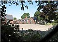
Bignold Primary School and Nursery
This is one of the schools that had stayed open for the children of key workers who required childcare so that they could keep working during the Coronavirus pandemic. Bignold Primary was scheduled to reopen on 1 June, but the school's website informed that they were not yet in a position to open more widely, as they were still waiting for safety materials, markings, barriers and other rigorous hygiene procedures to be completed. This meant that during the week beginning 1 June the school would only be open to key worker and other children who had been attending previously.
Image: © Evelyn Simak
Taken: 31 May 2020
0.03 miles
2
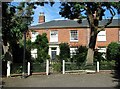
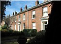
7 The Crescent, Chapelfield
The Crescent is a terrace of 17 houses, all dating from ca 1820 and Grade 2 listed.
Image: © Evelyn Simak
Taken: 5 Aug 2018
0.05 miles
3
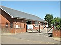
Entrance to Bignold Primary School and Nursery
Image: © Evelyn Simak
Taken: 31 May 2020
0.05 miles
4
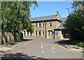
Chapelfield Methodist Church - Sunday School
As seen from Bristol Terrace. The Sunday School immediately adjoins the church > https://www.geograph.org.uk/photo/5865925.
Image: © Evelyn Simak
Taken: 31 May 2020
0.05 miles
5
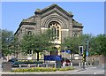
Chapelfield Road Methodist, Norwich
Chapelfield Road Methodist Church is located on Norwich's inner ring road, close to St Stephen's roundabout. It was opened in 1881, and built to seat almost 1,000 worshippers, its impressive frontage has remained unaltered although there have been considerable changes behind it, see church website www.chapelfieldroadmethodist.org.uk/
Image: © Graham Hardy
Taken: 10 May 2006
0.07 miles
6
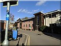
St Stephen's Medical Practice, Norwich
The St. Stephen's Medical Practice, on Wessex street in Norwich.
Image: © Sebastian Doe
Taken: 27 Oct 2019
0.07 miles
7
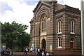
Chapel in the Field Methodist Church
Grade II listed. http://www.britishlistedbuildings.co.uk/en-228896-chapel-in-the-field-methodist-church-nor
Image: © N Chadwick
Taken: 29 Jun 2012
0.07 miles
8
Chapelfield - The Crescent
The Crescent is a terrace of 17 houses, all dating from ca 1820 and Grade 2 listed.
Image: © Evelyn Simak
Taken: 5 Aug 2018
0.07 miles
9
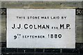
Chapel in the Fields Methodist Church - foundation stone
For a wider view of this location and some information see > http://www.geograph.org.uk/photo/5865925.
Image: © Evelyn Simak
Taken: 5 Aug 2018
0.08 miles
10
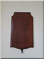
WW2 Memorial in Chapel Field Methodist church
The memorial bears four names, three servicemen and a female civilian.
Image: © Adrian S Pye
Taken: 14 Feb 2018
0.08 miles