IMAGES TAKEN NEAR TO
Hollow Lane, FAKENHAM, NR21 7ET
Introduction
This page details the photographs taken nearby to Hollow Lane, NR21 7ET by members of the Geograph project.
The Geograph project started in 2005 with the aim of publishing, organising and preserving representative images for every square kilometre of Great Britain, Ireland and the Isle of Man.

There are currently over 7.5m images from over14,400 individuals and you can help contribute to the project by visiting https://www.geograph.org.uk
Image Map
Images are licensed for reuse under creativecommons.org/licenses/by-sa/2.0
Notes
- Clicking on the map will re-center to the selected point.
- The higher the marker number, the further away the image location is from the centre of the postcode.
Image Listing (14 Images Found)
Images are licensed for reuse under creativecommons.org/licenses/by-sa/2.0
Image
Details
Distance
1
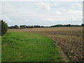
Harrowed field and the edge of West Raynham
Image: © Jonathan Thacker
Taken: 6 Sep 2022
0.13 miles
4
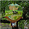
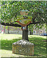
The Raynhams village sign
At the very top is the emblem of the Royal Air Force in remembrance of RAF West Raynham. It is no surprise Raynham Hall features boldly on the sign, it has been the home of the Townshend family for 400 years. Sheep also feature large in the grounds of the hall keeping the grass trim. Also depicted are a team of black horses drawing a furrow. The crops shown are turnip, wheat, barley and oats, with peas and clover thrown in for good measure.
Image: © Adrian S Pye
Taken: 9 Jul 2015
0.20 miles
5
The Raynhams village sign
The single sign serves for the three villages of East, South and West Raynham.
Image: © Adrian S Pye
Taken: 9 Jul 2015
0.20 miles
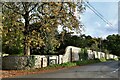
6
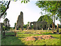
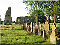
The ruins of St Margaret's church in West Raynham - churchyard
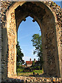
View across the churchyard and towards the cottages beyond as seen by looking through one of the nave south windows of the ruined church > http://www.geograph.org.uk/photo/1938746. The ruin of St Margaret's church has recently been made safe for visitors. Trees growing in chancel and nave have been cut down, a modern altar has been placed at the east end and a 'font' was reconstructed by using two capitals and a column section. The church - it was abandoned in the 18th century when the parish was consolidated with East Raynham consisted of a west tower, nave and chancel and its outline can still be clearly discerned.
Image: © Evelyn Simak
Taken: 27 Jun 2010
0.23 miles
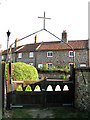
7
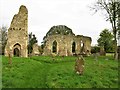
Ruins of St Margaret's Church, West Raynham
Also known as Little Raynham Church, the remains of the medieval St Margaret's Church, probably 14th and 15th century, are a Grade II listed building. https://www.britishlistedbuildings.co.uk/101049279-church-of-st-margaret-raynham#.WfoeHjFLE5s
Image: © G Laird
Taken: 26 Oct 2017
0.23 miles
8
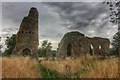
St Margaret church ruin, West Raynham
Ruin of 11th century church.
Image: © Inkedmik
Taken: 5 Aug 2015
0.24 miles
9
The ruins of St Margaret's church in West Raynham
The ruin of St Margaret's church has recently been made safe for visitors. Trees growing in chancel and nave have been cut down, a modern altar has been placed at the east end and a 'font' was reconstructed by using two capitals and a column section. The church - it was abandoned in the 18th century when the parish was consolidated with East Raynham consisted of a west tower, nave and chancel and its outline can still be clearly discerned.
Image: © Evelyn Simak
Taken: 27 Jun 2010
0.24 miles
10
The ruins of St Margaret's church in West Raynham
The ruin of St Margaret's church has recently been made safe for visitors. Trees growing in chancel and nave have been cut down, a modern altar has been placed at the east end and a 'font' was reconstructed by using two capitals and a column section. The church - it was abandoned in the 18th century when the parish was consolidated with East Raynham consisted of a west tower, nave and chancel and its outline can still be clearly discerned.
Image: © Evelyn Simak
Taken: 27 Jun 2010
0.24 miles